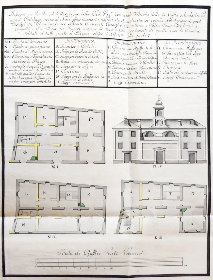
Plan and longitudinal section of the Royal Commercial Culla factory/workshop, situated on the square at Karlobag near the sea, with a proposal for its rebuilding, repair and enlargement to provide more suitable accommodation for the royal commander. Separate council chambers, offices and residential rooms are provided, together with rooms for the council and judges, a space for the lifting wheel or loading apparatus, its store, and quarters for the military guard, all arranged according to the plan and its alphabetical key through the letter Z.
Scale: twenty Viennese fathoms.
Source: Croatian State Archives (HDA), Zagreb.
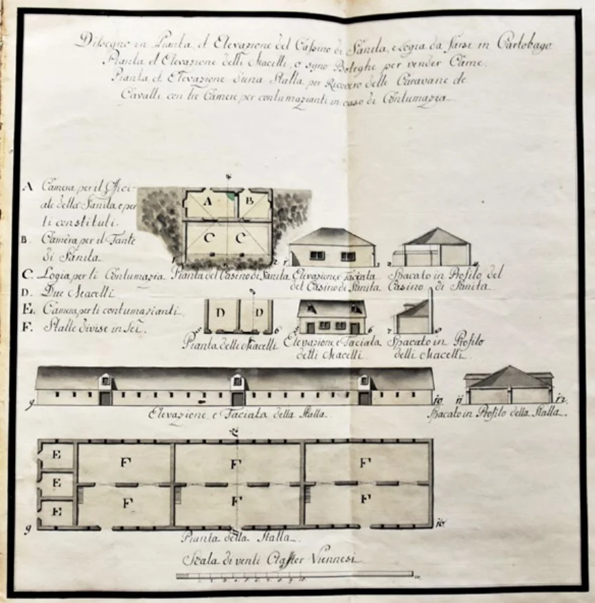
Translation of the text on the drawing:
- Plan and elevation of the Health House (Casa di Sanità) and loggia to be built at Karlobag.
- Plan and elevation of the slaughterhouses and the adjoining shops for the sale of meat.
- Plan and elevation of a stable for caravan horses, with two rooms for sick persons in the event of quarantine or contagion.
Left:
- A. Room for the chief sanitary officer (Health Magistrate) and detained persons. (The official responsible for quarantine, together with travellers or staff under observation.)
- B. Room for the sanitary lieutenant. (An assistant official responsible for enforcing health and quarantine regulations.)
- C. Loggia for persons in quarantine. (An open, ventilated area for those kept in isolation.)
- D. Two slaughterhouses.
- E. Room for persons in quarantine. (Isolation room for suspected or sick cases.)
- O. Staircase leading to the second floor.
- F. Stables divided into six bays. (Compartments within the caravan stable.)
Scale: twenty Viennese fathoms.
The Health House (Casa di Sanità) in Karlobag (1757)Detail from the combined plan shown above.
The plan of the Health House (Casa di Sanità), marked A, B and C, together with its elevation and section, shows a key building in the system of movement and health control. The health office or pavilion was to stand immediately beside the sea, east of the small harbour basin and below the parish church of St Charles Borromeo.
The building was conceived as a simple rectangular single-storey structure beneath a hipped roof, with an interior layout determined by its quarantine function:
- Officers’ rooms (A and B): two rooms were reserved for the staff of the health office—the chief sanitary officer (A) and the sanitary lieutenant (B), who supervised the enforcement of the regulations.
- Quarantine loggia (C): a large part of the building was occupied by a loggia intended for the accommodation and isolation of infected or suspected persons (contumaci), providing a separate and well-ventilated space during quarantine.
The building would have formed an obligatory control point for everyone entering Karlobag, enforcing the strict sanitary cordon of the Habsburg Monarchy.
The Slaughterhouses (Macelli) in Karlobag (1757)Detail from the combined plan shown above.
The plan of the two slaughterhouses (Macelli) and butcher shops, marked D, together with the elevation and section, illustrates an important element in the regulated meat trade. The butcheries were to stand close to the main square, behind the commander’s residence, their rear walls adjoining the public building in which he lived. The structure was conceived as a single-storey building divided by a partition wall and covered by a mono-pitched roof with a roof light.
The Horse Stables (Stalle) in Karlobag (1757)Detail from the combined plan shown above.
The plan of the horse stable and quarantine rooms for people arriving in the town, marked E and F, together with its elevation and section, shows a building intended to accommodate travellers and their animals. The large stable for horses and caravans was to be erected at the northern entrance to Karlobag, near the site of today’s small chapel above Fortica. It was designed as an elongated single-storey structure divided into six large stable bays beneath a gabled roof with roof lights. Three rooms for infected travellers were placed at its southern end.
Source: Croatian State Archives (HDA), Zagreb.
Reconstruction of Fortica in Karlobag (1757)
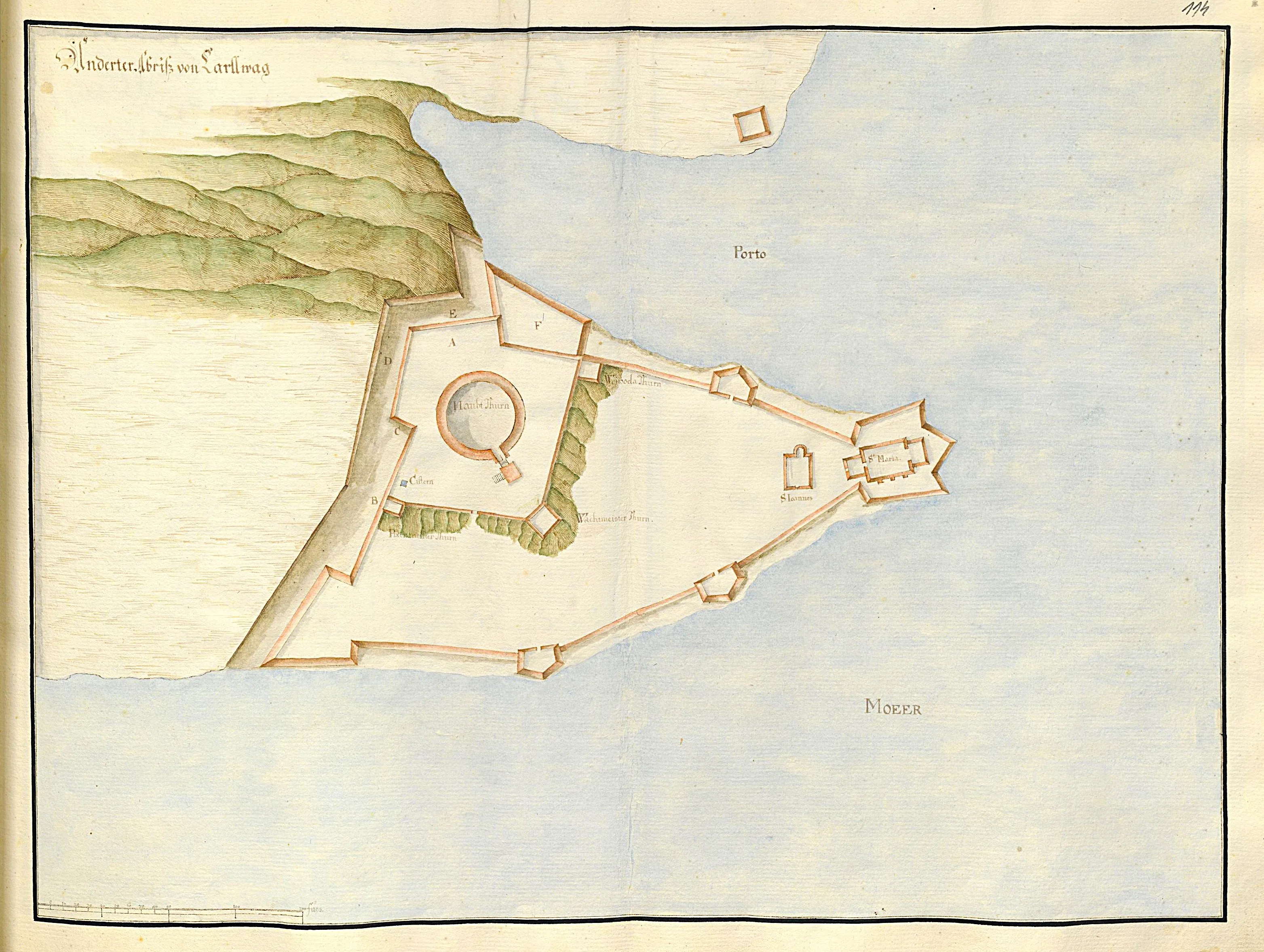
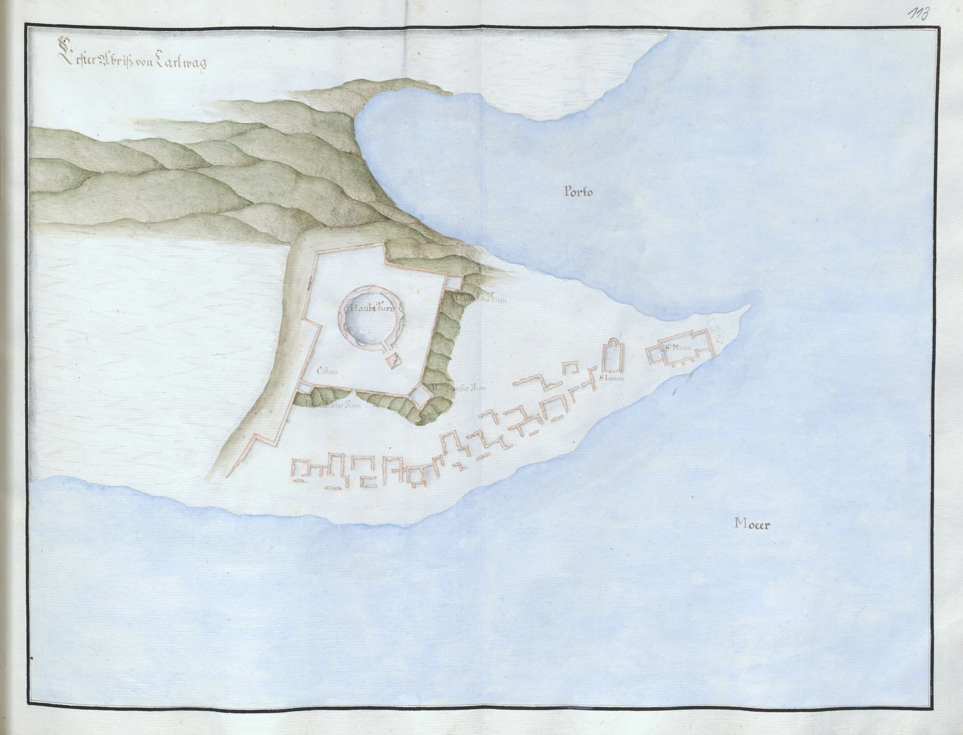
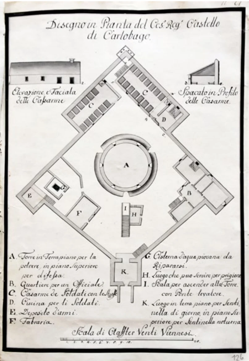
Antonio Michelazzi, 1757. – In 1757 the celebrated imperial engineer Antonio Michelazzi completed this precise design for the Imperial-Royal fortress at Karlobag. The drawing is more than a representation of fortifications; it is a vision of order. Michelazzi carefully mapped the principal stronghold and its supporting buildings: soldiers’ barracks (Casarme de Soldati), a kitchen (Cucina per li Soldati), an arms store (Deposito d’armi) and the main powder tower (Torre in Terraplano), all arranged within a rhomboid defensive enclosure.
The sections (Spacato in Profilo) and elevations (Elevazione e Facciata) show that the scheme was conceived both as a strong, functional defensive position and as an architectural symbol of Habsburg authority on the Adriatic.
Source: Croatian State Archives (HDA), Zagreb.
Translation of the text on the drawing:
- Imperial-Royal Fortress at Karlobag (Ces: Reg: Castello di Carlobago).
Left side:
- A. Tower: powder store on the ground floor and a defensive chamber above.
- B. Quarters for one officer.
- C. Soldiers’ barracks with their cisterns.
- D. Soldiers’ kitchen.
- E. Arms store.
- F. Forge.
Right side:
- G. Rainwater cistern to be repaired.
- H. Room that may serve as a prison.
- I. Staircase to the tower with a drawbridge.
- K. Ground-floor room for the day guard, with the night guard above.
Scale: twenty Viennese fathoms.
Michelazzi redesigned the neglected castle on the hill above Karlobag, recording the existing condition and adding barracks along the northern side of the complex at an estimated cost of 1,000 florins. Around the older cylindrical tower at the heart of the fortress he formed a castle plan resembling a rotated square, with rectangular towers at the corners. The entrance lay on the south, through a tower containing the day guard on the ground floor and the night guard above. The central tower housed the powder magazine below and a defensive chamber on the upper level, reached from the courtyard by a stone stair and drawbridge. Michelazzi proposed a prison beside this stair. The eastern side of the courtyard was occupied by a two-storey range with five rooms for an officer, while the western side contained a forge, cistern and external stair leading beside the corner tower that housed the armoury. Finally, two separate single-storey ranges were added against the walls in the northern corner as heated soldiers’ sleeping quarters; the north-eastern range also contained a kitchen with a fireplace.
Karlobag’s Water Supply: Michelazzi’s Engineering Solution (1756)
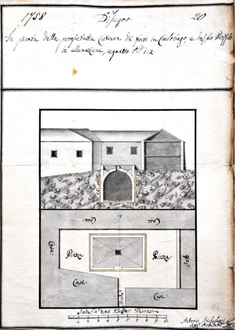
Antonio Michelazzi, 1757. – Plan of the proposed cistern and its sectional view.
Source: Croatian State Archives (HDA), Zagreb.
In 1756 Karlobag faced an acute shortage of drinking water. In response to the crisis, Michelazzi arrived in the town on 30 August on the orders of the imperial commander. His task was crucial: to identify a site for a large new cistern and devise a solution for repairing the existing water infrastructure.
The New Cistern Project
Michelazzi selected a deserted square in the centre of the town, measuring 12 by 6 Klafter and surrounded by ruined houses. He proposed a cistern 5 by 3 by 3 Klafter in size, capable of holding more than 5,000 barrels of water. Even this, he believed, would not fully satisfy the needs of the population; the cost of construction was estimated at a substantial 2,000 florins.
Repairing and Rehabilitating the Old Cistern
At the same time Michelazzi stressed the need to repair the old town cistern, probably at the northern end of the main square. Stagnant water and fouled channels were the principal problems. His programme called for draining the old water, clearing debris from the channels, reshaping the reservoir into a regular square, lining it with lime and clay for insulation, repairing the suspended roof gutters that collected rainwater, and rebuilding the pump area.
The repair and modernisation of the old cistern was estimated at a further 1,000 florins. The following year Michelazzi formalised his findings from August by submitting a signed design for the cistern, complete with plan and section, bringing the Karlobag water-supply scheme into formal consideration.
Competition and Financial Constraints: Michelazzi’s Proposals Rejected
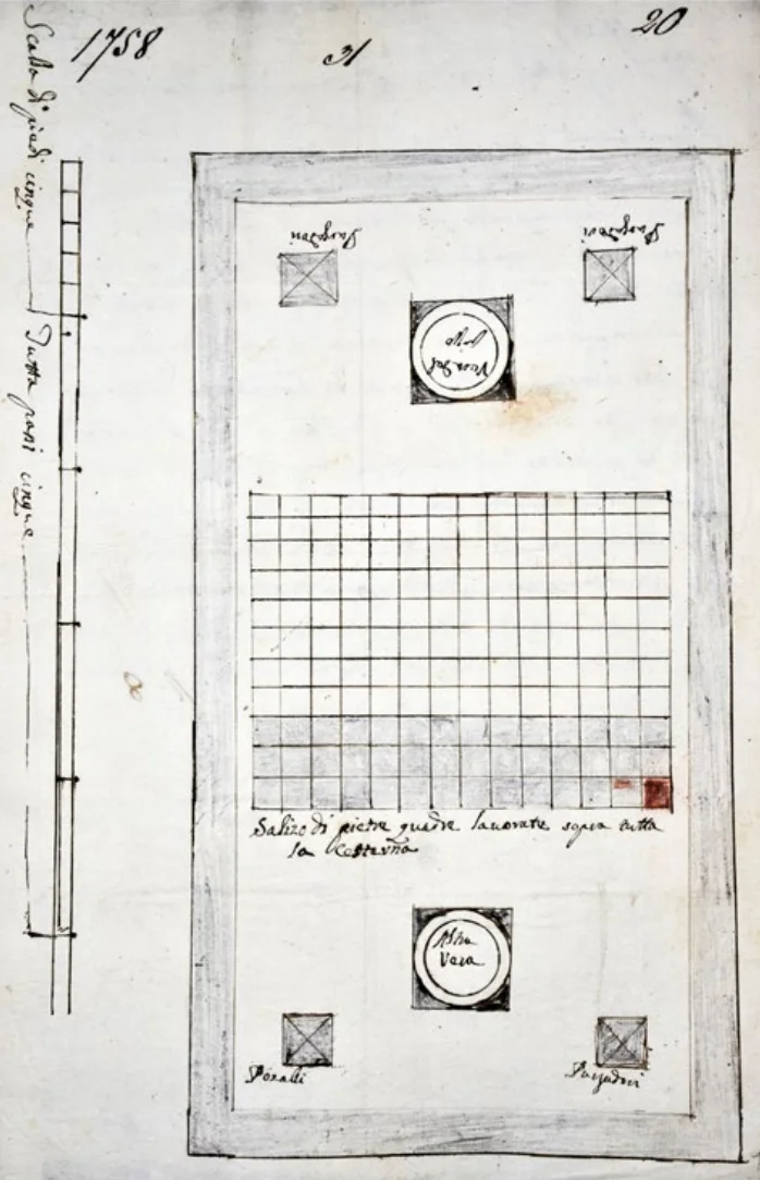
Roko Stuparić of Veli Lošinj, 1757 – Plan of the proposed new cistern
Source: Croatian State Archives (HDA), Zagreb.
Although Michelazzi had prepared detailed proposals for the castle and water supply, the high costs and reservations of the local administration created substantial opposition.
To avoid the expense of Michelazzi’s scheme, the local administration invited another specialist in 1757—master builder Roko Stuparić of Veli Lošinj—who submitted his own design and estimate for a new cistern.
Stuparić proposed a cistern 30 feet long, 15 feet wide and 12 feet high, with a capacity of about 3,600 barrels of water. The cost was estimated at 1,611 ducats. His estimate specifically included two large carved stone wellheads and square stone slabs for paving the terrace above the reservoir.
The local official Mateo Diminić openly supported Stuparić in his report of March 1758, describing him as a specialist who had built cisterns throughout Dalmatia. He noted that Stuparić had already constructed the cistern on Karlobag’s main square and three others in the town. On the strength of that reputation, Diminić recommended that he also be entrusted with the new cistern.
Stuparić’s design is believed to have been carried out, since a cistern with stone paving and two carved wellheads survives in today’s Ivana Vrbana Street, close to the town square.
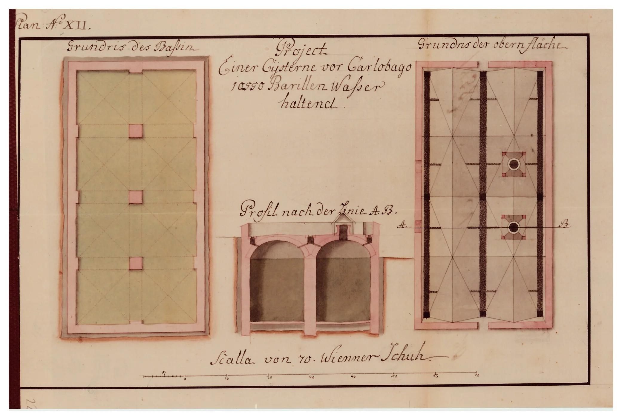
Engineering Solution: Water Cistern Project (1758)
This 1758 cistern project demonstrates how essential a reliable water supply was to the survival and development of Karlobag. Its evolution also illustrates the careful management of state resources. Michelazzi’s initial vision of 1756 proved too costly for contemporary circumstances, and in 1757 Roko Stuparić—known for more economical solutions—was brought in to adapt the scheme to realistic means. The resulting 1758 design represents a carefully judged compromise between essential functionality and the strict financial discipline of the Viennese court.
The drawing presents a sophisticated structure: “Grundris des Bassin” (plan of the basin), “Grundris der obern Fläche” (plan of the upper surface) and “Profil nach der Linie A.B.” (section along line A–B). Two vaulted chambers divided by supporting piers provided secure storage for as many as 10,550 barrels of water. Built into the ground beneath carefully formed vaults, the structure reveals the engineering expertise required to secure water reserves in a karst landscape where every spring was strategically important.
The document is more than a technical drawing: it records an attempt to overcome the constraints of the karst environment. As Karlobag developed into a commercial and military node, drinking water became a strategic concern. The cistern therefore represents fundamental infrastructure without which the barracks in the Culla, the road network and other public facilities would have been far more difficult to sustain.
The cistern project also reveals the high construction standards expected by the Monarchy in its coastal outposts. Through the carefully drawn plan and section, every element of the structure—from foundations and vaulting to the openings through which water was drawn—was recorded with the knowledge that the stability of the town depended on precise planning.
Ultimately, the document reflects a vision of Karlobag as a town whose survival would rest not on chance but on engineering. The precision with which a capacity of 10,550 barrels was calculated underlines the project’s importance to the daily life of both garrison and townspeople. It evokes an age in which every Viennese Klafter and every drop of water was planned with remarkable care, making the drawing an important witness to the history of Lika and the Croatian Littoral.
Source: Austrian State Archives, Vienna.
Military Architecture: Converting the Culla into Barracks (1759)
This 1759 drawing is a key document in Karlobag’s transformation from a commercial town into an important military and administrative centre of the Monarchy. Whereas Michelazzi’s 1757 plan presents the initial vision, the 1759 scheme (Idee nach welcher die Culla zu Carlobago zu einer Casarne... zu erweitern und einzurichten wäre) records the concrete engineering changes required to convert the building into functional barracks for an entire company. Every part of the structure—from ground-floor stores to officers’ quarters above—had to be reorganised to meet strict military requirements.
The plan carefully sets out accommodation for groups of 44 to 80 soldiers, quarters for officers such as lieutenants and captains, and essential hygienic and logistical spaces including a hospital, kitchens and latrines. Particularly revealing are the annotations marked “K – Neue Maueren”, showing where existing partitions were to be removed and new walls constructed. The adaptation was therefore far more than cosmetic: it amounted to a complete change of function that reinforced Karlobag’s role as a military stronghold beneath Velebit.
The document is an important witness to the gradual militarisation of the town. Plans that carefully allocated accommodation to soldiers and officers created the conditions for a permanent garrison responsible for controlling the routes towards the interior. Here the Culla is captured at the moment of its conversion, part of the wider transformation of Karlobag during the eighteenth century.
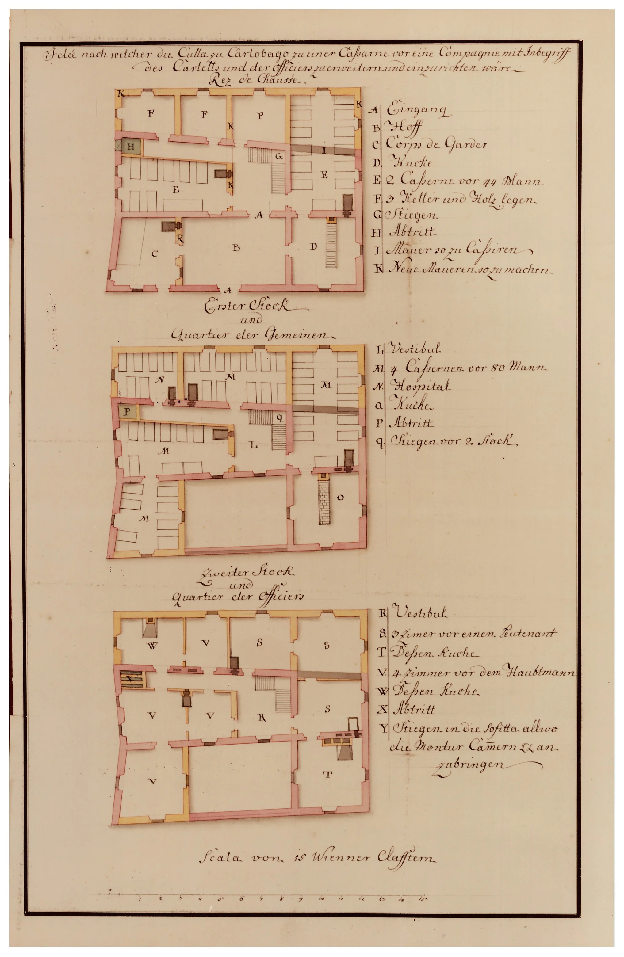
The conversion plan goes beyond a simple arrangement of rooms, revealing the complex military logistics required for life and service in frontier Karlobag. It also illustrates the engineering standards imposed by the Viennese authorities on their coastal outposts, where every interior—from armouries to officers’ accommodation—was planned with exacting precision.
See the original 1757 plan of the Culla for comparison with this later military conversion.
Arrangement of the Barracks (1759):
- Ground floor (Quartier der Gemeinen): Entrance, courtyard, accommodation for 44 soldiers (E), cellars and wood stores (F), staircases (G), and latrines (H).
- First floor (Quartier der Gemeinen): Accommodation for 80 soldiers (M), hospital (N), kitchen (O), and latrines (P).
- Second floor (Quartier der Officiers): Officers’ apartments (S, V), kitchens (T, W), latrines (X), and a staircase leading to the attic (Y), intended for the storage of military equipment (Montur Camern).
Ultimately, the document reflects a vision of Karlobag as a modern military centre. The clarity of the drawing and the precise indications for the new walls (K – “Neue Maueren”) give the plan particular historical weight, confirming its status as a state project of considerable importance that permanently changed the character of the Culla.
Source: Austrian State Archives, Vienna.
Architectural Vision: Parish Church of St Charles Borromeo (1765)
This architectural drawing of 1765 is an invaluable record of a period in which Karlobag was being deliberately shaped as an important administrative and religious centre of the Monarchy. Although the plan is labelled “Parochiale Chiesa”, its real significance lies in the engineering precision with which the town’s principal church was conceived. The document preserved in Vienna shows that the building was intended not only as a place of worship, but also as a representative work of architecture conforming to the high standards of contemporary Baroque construction. In character, the project belongs to the wider programme of architectural interventions begun in Karlobag in the mid-eighteenth century, among which Antonio Michelazzi’s 1757 designs for the Culla occupy a particularly important place.
Unlike improvised places of worship, this design follows the disciplined logic of Baroque symmetry and function. The drawing carefully records the ground plan (A), nave (B) and sanctuary (C), while also supplying practical instructions to the builders, including notes concerning changes to the colour of certain decorative elements. Such meticulous communication between designer and craftsmen was essential to the execution of a building intended to embody the stability and progress of contemporary Karlobag.
The document is, in a sense, an architectural signature of its age. Its precise drawings—from the position of the organ to the vertical sections—reveal the degree of preparation required for construction in the demanding climate beneath Velebit. The church is shown at a moment when Karlobag was being transformed into a deliberately planned settlement, shortly before further improvements to infrastructure and road communications strengthened its position within the Monarchy.
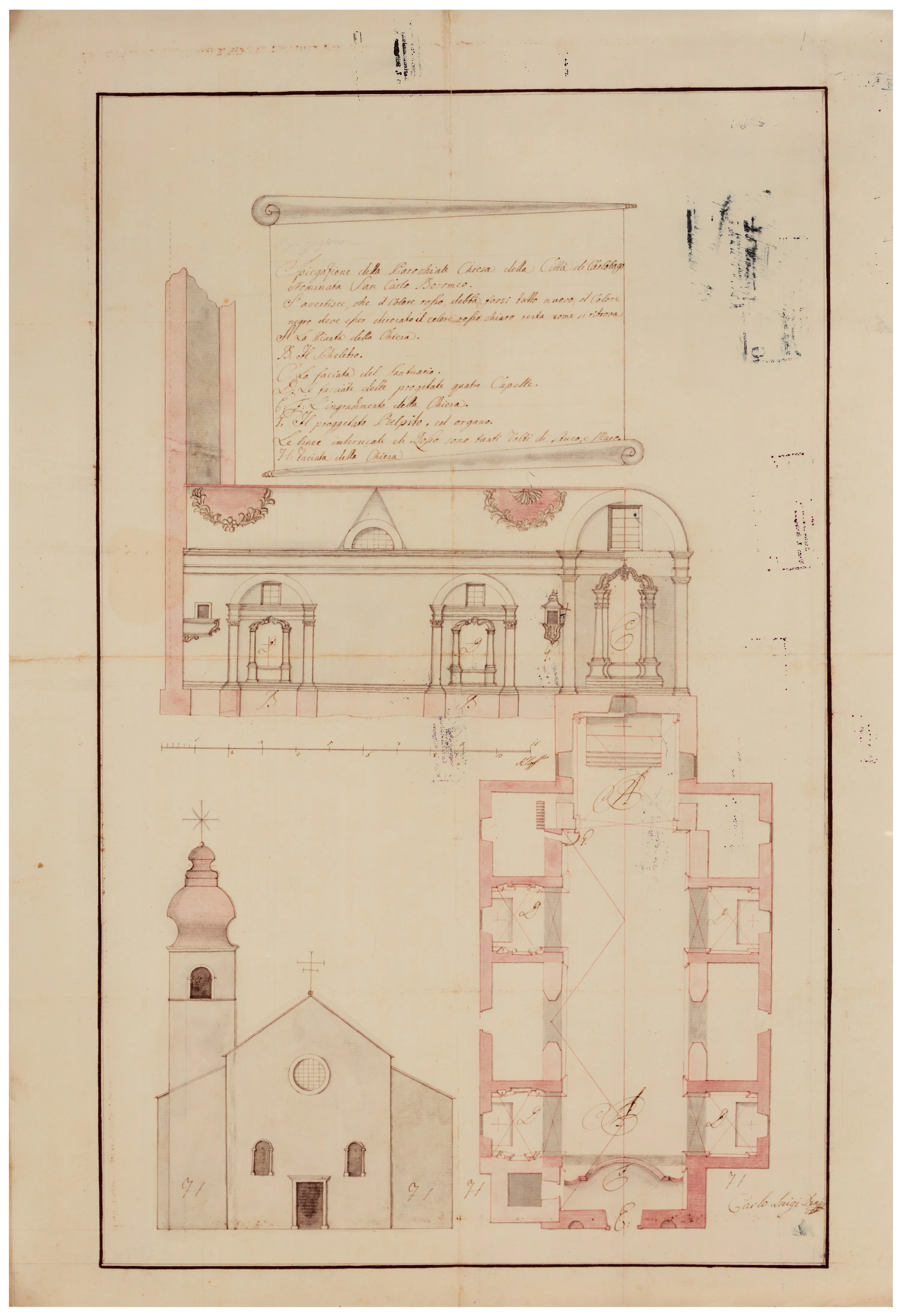
The drawing reaches well beyond the mere tracing of walls and opens a window onto the complex planning of Karlobag’s urban core. Although the parish church of St Charles Borromeo is its principal subject, the document also illustrates the engineering and aesthetic standards promoted by the Viennese court in its frontier territories. Carefully drawn legends and instructions record the interior in detail, reflecting an understanding of the church as both a visual landmark and a social centre around which the community gathered.
Ultimately, the drawing embodies a vision of Karlobag as a modern centre whose development depended on the close relationship between careful design and skilled execution. The clarity of the draughtsmanship and precision of the annotations give the plan a distinctly human dimension while underlining the project’s importance to the state. Through its plans, sections and architectural details, we encounter an age in which everything—from the colour of decorative elements to the position of the altar—was considered with remarkable care, making this one of the most eloquent architectural witnesses to the history of Lika and the Croatian Littoral.
Source: Austrian State Archives, Vienna.
Between the Carolina and the Theresiana: Rebuilding the Old Road (1770)
This geographical map of 1770 records an attempt to adapt the old route of 1752 to the changing economic requirements of the Monarchy. Although it is described on the map as the “new commercial road” (neue Commercial-Strasse), the document in fact reflects efforts to improve, widen and better connect the existing, exceptionally steep Carolina Road with the administrative centre at Gospić.
Unlike Vukasović’s later road, this scheme still follows the older logic of forcing a passage across Velebit. The route struggles with heights such as Belebiza Glaviza and Eedezik, and its bends are sharper and more direct, making the journey extremely demanding for heavily laden merchant wagons. The map carefully records military watchposts and settlements, as well as water sources near Oštarije that were vital to both travellers and animals on this difficult road.
The document is also a record of the limitations of the old route. Its weaknesses were already evident by 1770—from excessive gradients to the difficulty of keeping it usable through the winter—and these shortcomings helped create the pressure that would lead, little more than a decade later, to the construction of the modern Theresiana Road. The map captures Lika and Karlobag at the point when the older road system had reached its limits, shortly before the engineering brilliance of Filip Vukasović transformed travel across Velebit.
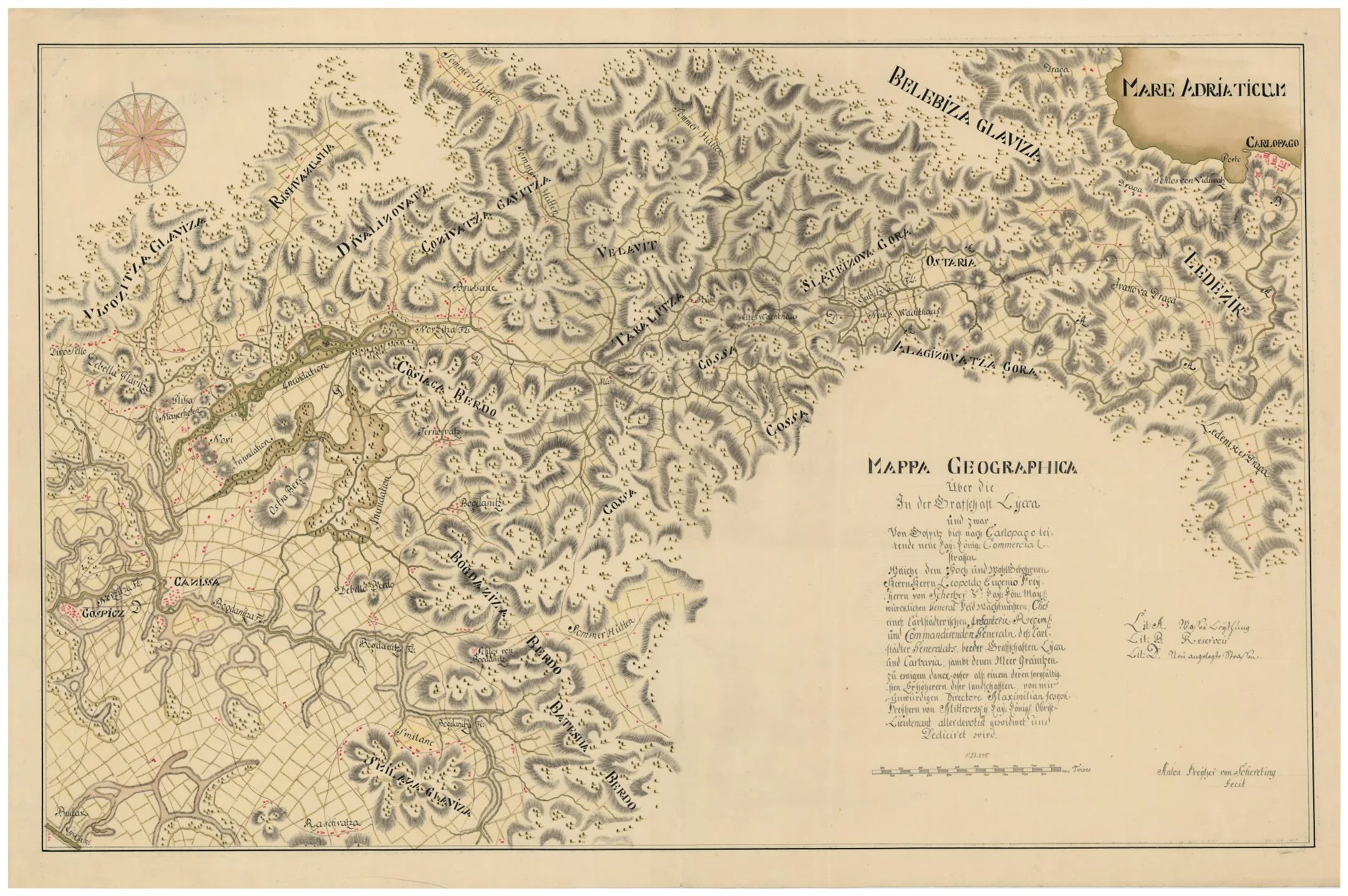
More than a map of roads, this document reveals the wider infrastructure required for life and movement through the karst of Velebit. Its principal subject is the Imperial-Royal commercial road linking Gospić and Karlobag, yet it also records proposed solutions for water supply—without which regular traffic across the mountain would have been impossible. Reservoirs and water conduits are carefully plotted, reflecting the engineers’ awareness that every merchant wagon and every traveller depended on these critical points in an arid landscape.
Ultimately, the map expresses a vision of Karlobag as a modern commercial centre whose growth depended on the combined strength of engineering and logistics. Lieutenant Colonel Mitterssky’s dedication to General Scherzer adds a personal dimension to a project of clear state importance. Roads, water and strategic positions are brought together in a document from an age in which every kilometre of route and every available source of water had to be planned with exceptional care.
Source: Austrian State Archives, Vienna.
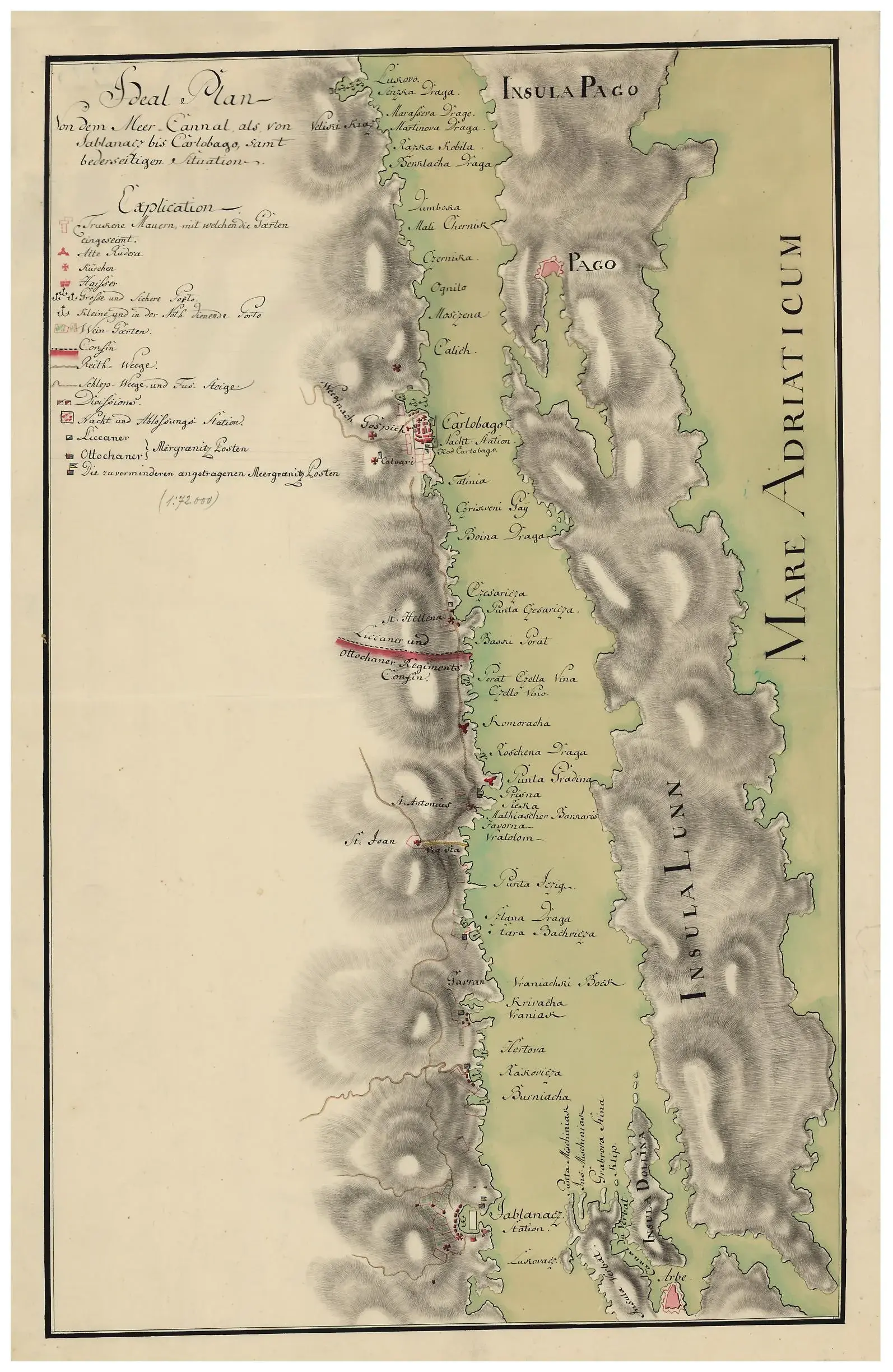
A Vision in Stone: The Dream of the Coast Beneath Velebit (1773)
The 1773 plan belongs to a period of intensive Habsburg efforts to organise the coast beneath Velebit more effectively for transport and defence. An imperial engineer recorded the stretch between Jablanac and Karlobag, where the steep slopes of Velebit descend directly to the sea, and transformed it into an “Ideal Plan” for the future development of the coast.
At the time, the coast beneath Velebit was a demanding and poorly connected frontier zone. The Lika and Otočac regiments named in the legend operated in a landscape defined by karst, fierce bora winds and limited communications. The engineer therefore marked small harbours and shelters for vessels, together with footpaths that could form the basis of a future road network.
The symbols on the map record important elements of the contemporary landscape: churches, dry-stone walls, settlements, paths and coastal shelters. The “Ideal Plan” represents an attempt to organise the territory systematically and connect the Adriatic shore with the interior, assigning a greater transport and economic role to its remote coves.
More than two centuries later, the document remains a compelling record of an ambitious attempt to plan the development of the coast beneath Velebit. Its lines show how transport, seafaring and the organisation of space were imagined at a time when every intervention in the karst demanded considerable technical skill and organisation.
This historic document of 1773 presents a visionary “Ideal Plan” of the Adriatic coast between Jablanac and Karlobag. Created at the height of Habsburg efforts to master the Velebit karst, it is not merely a geographical representation but a strategic design for connecting the interior with the sea.
The map carefully records both contemporary reality and future ambitions: from safe harbours and shelters from the bora, through frontier posts of the Lika and Otočac regiments, to laboriously built dry-stone walls and footpaths. Written in elegant script, it remains an enduring witness to an age in which the future of modern trade and seafaring was being drawn into the harsh stone landscape.
Source: Austrian State Archives, Vienna.
Between Mountain and Sea: An Engineering Dream for Karlobag
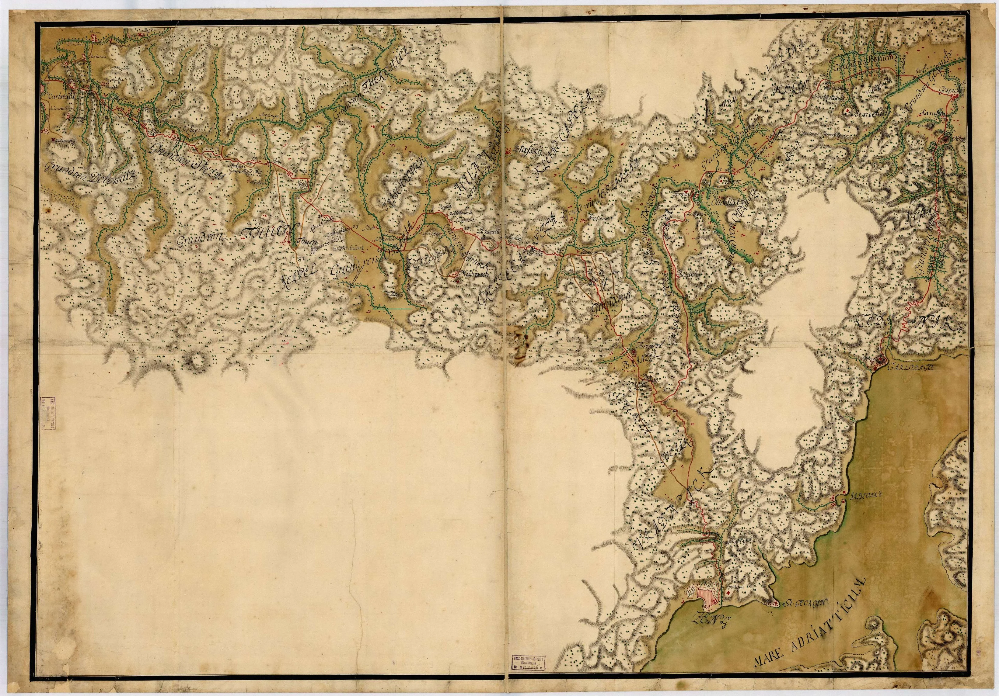
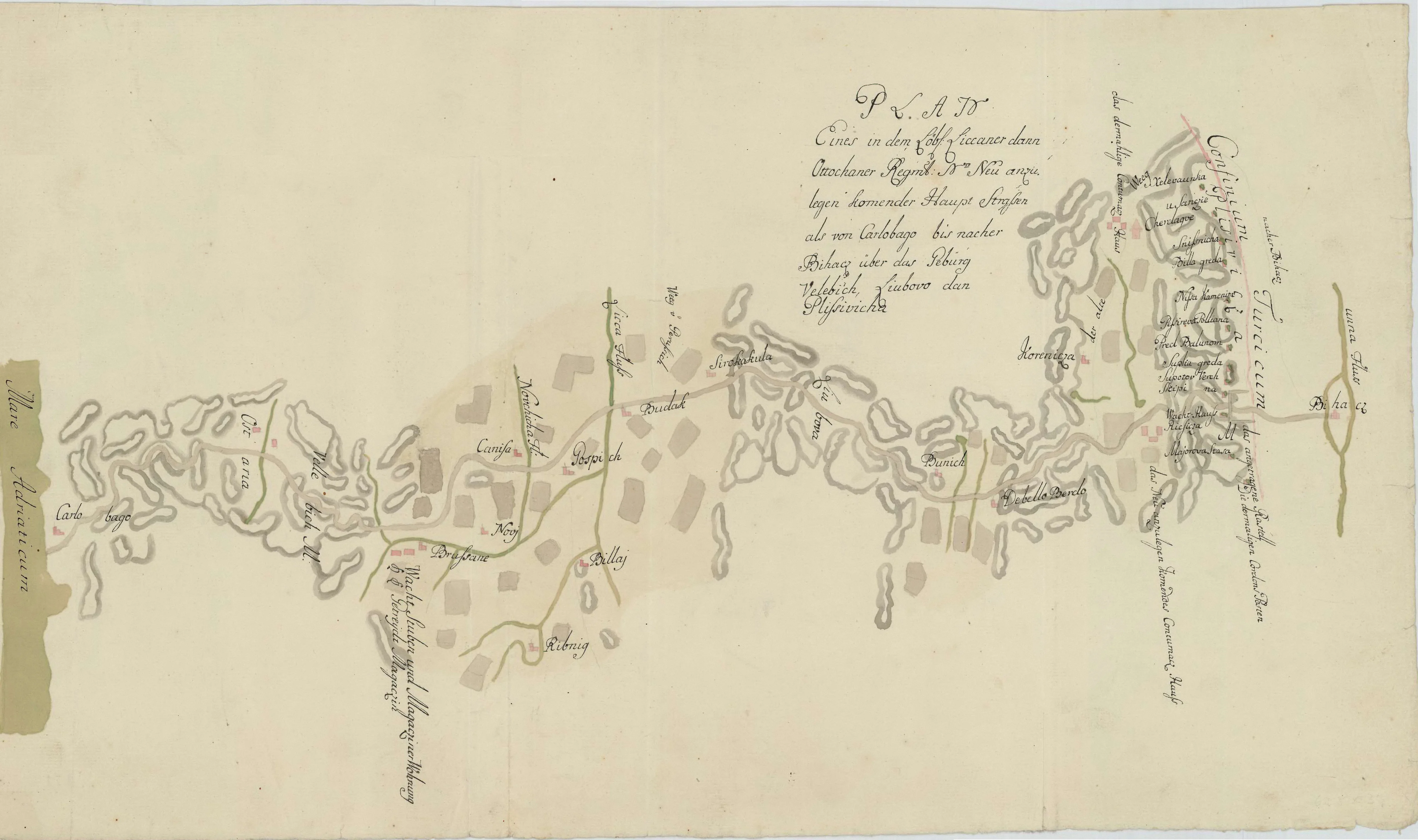
The story begins in 1746, when the Habsburg Monarchy made a bold decision: to connect the Adriatic coast directly with Bihać. The proposed route was not merely a commercial road but a military imperative, required to cross three formidable natural barriers—the rugged heights of Velebit, the Ljubovo plateau and the Plješivica massif.
The original manuscript plans trace a line from the Adriatic to the fortifications of the “Turkish frontier” (Confinium Turcicum). It was an attempt to overcome Lika’s isolation and draw the region into the main network of European communications. Yet the early route remained steep and extremely difficult for heavy wagons: the natural terrain still exceeded the engineering possibilities of the day.
Three great arteries can be read in these faded lines:
The Road of 1752
Marked as the “old road” (alte Straße), it followed steep natural gullies and cuts. Travel across the karst was an ordeal, with gradients that heavily laden wagons could scarcely negotiate.
The Theresiana Road of 1786
The work of the brilliant Filip Vukasović. Shown as the newest road of its time, it introduced sweeping bends and gentler gradients, creating the first truly practicable route across Velebit.
The Proposed New Road
The most ambitious line on the map—a vision of a modern main road intended to continue towards Gospić.
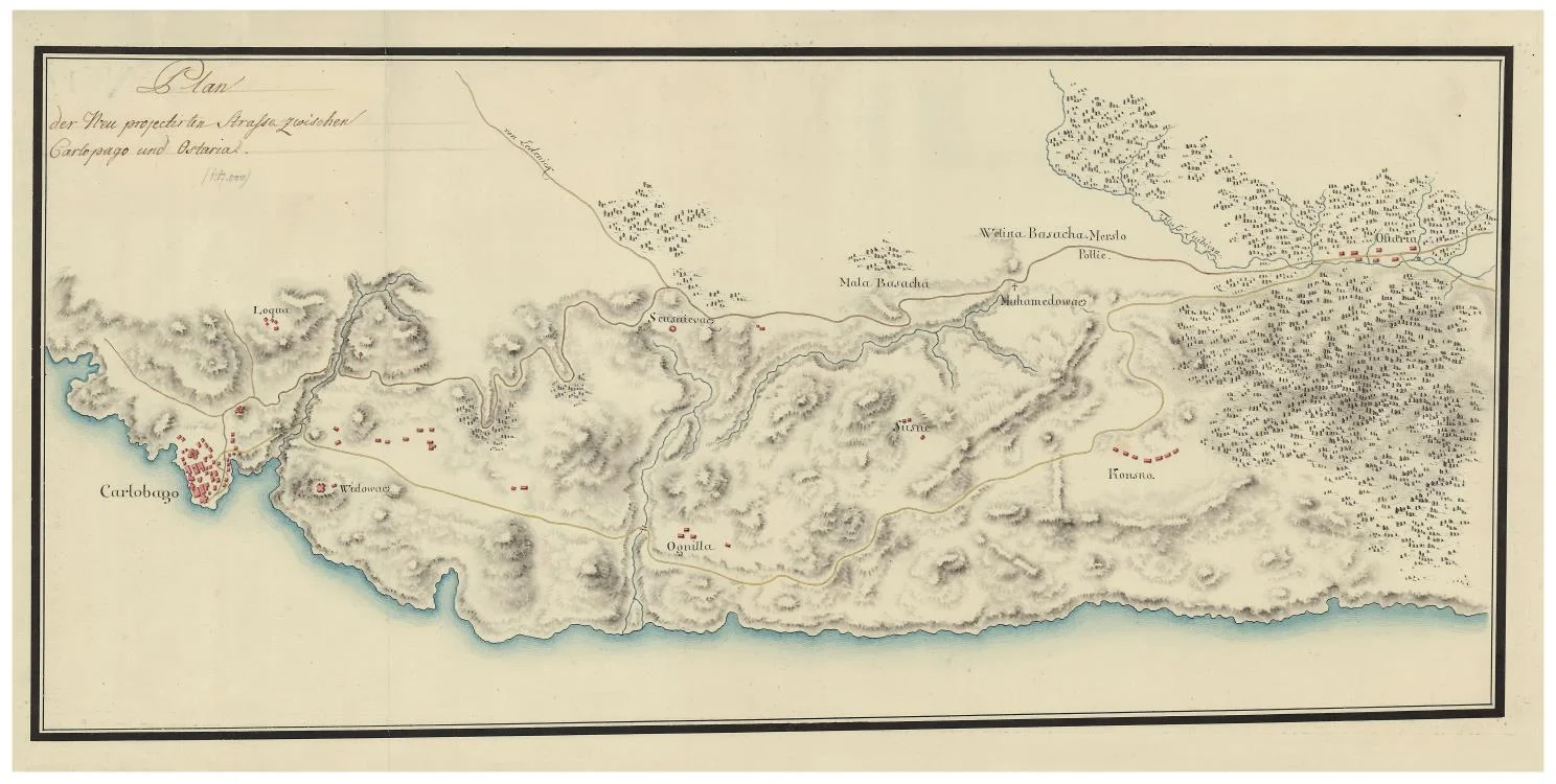
Survey Plan of the New Road from Karlobag (Carlopago) to Oštarije, 1786
This technical drawing represents the culmination of planning for a new main road between Karlobag and Oštarije. It captures the moment when imperial engineers sought a permanent solution to the severity of the Velebit massif. Unlike earlier roads that attacked the mountain directly, the new route climbs in broad curves and gentle gradients better suited to heavy merchant wagons. The meticulously rendered terrain—including Velika and Mala Basača and settlements such as Vidovac and Konjsko—reveals a deep understanding of the landscape and a determination to turn natural obstacles into engineering advantages.
At the heart of the plan is an ambitious vision of linking Lika with the coast, transforming the road from a local route into a strategic commercial artery. Particular attention was paid to logistics: systems for lowering materials into Velika Draga Bay and networks of cisterns designed to address the chronic shortage of water. Every line—from precise sea-level measurements to mountain springs that remained beyond the town’s reach—belongs to a wider scheme intended to turn Karlobag into a modern northern Adriatic port and a key junction towards Zadar and the interior.
Source: Austrian State Archives, Vienna.
IV
Comparing the Historic Plans
From Vision to Realisation
Comparing the plans of 1757 and 1758: an ambitious vision and the works actually carried out
Following Michelazzi’s individual projects, the exhibition places two plans of Karlobag directly side by side. The 1757 plan presents an extensive urban vision, while the plan of 1758 shows how the programme was adapted to the existing town, the available funds and the most immediate needs.
Michelazzi’s proposals were incorporated into the 1757 plan of Karlobag. They provide crucial evidence of his involvement and make the contrast between ambitious design and eventual realisation especially clear:
-
Plan of 1757 (vision)
:
This map brings together Michelazzi’s principal proposals in a single document, including the reconstruction of the castle, a new cistern and administrative buildings. The projects are carefully drawn and described on the right-hand side of the map, preserving the full scale of the vision the Monarchy hoped to realise.
-
Plan of 1758 (realisation)
:
This plan records the actual state of the works. It shows which parts of Michelazzi’s ambitious programme were carried out and which had to be abandoned because of financial and logistical constraints.
V
A New Era of Roads and Harbour Works
Karlobag in the 19th Century – Harbour, Transport and Modernisation
Plans and documents tracing Karlobag’s transition from a fortified frontier settlement to a more modern centre of transport and maritime activity.
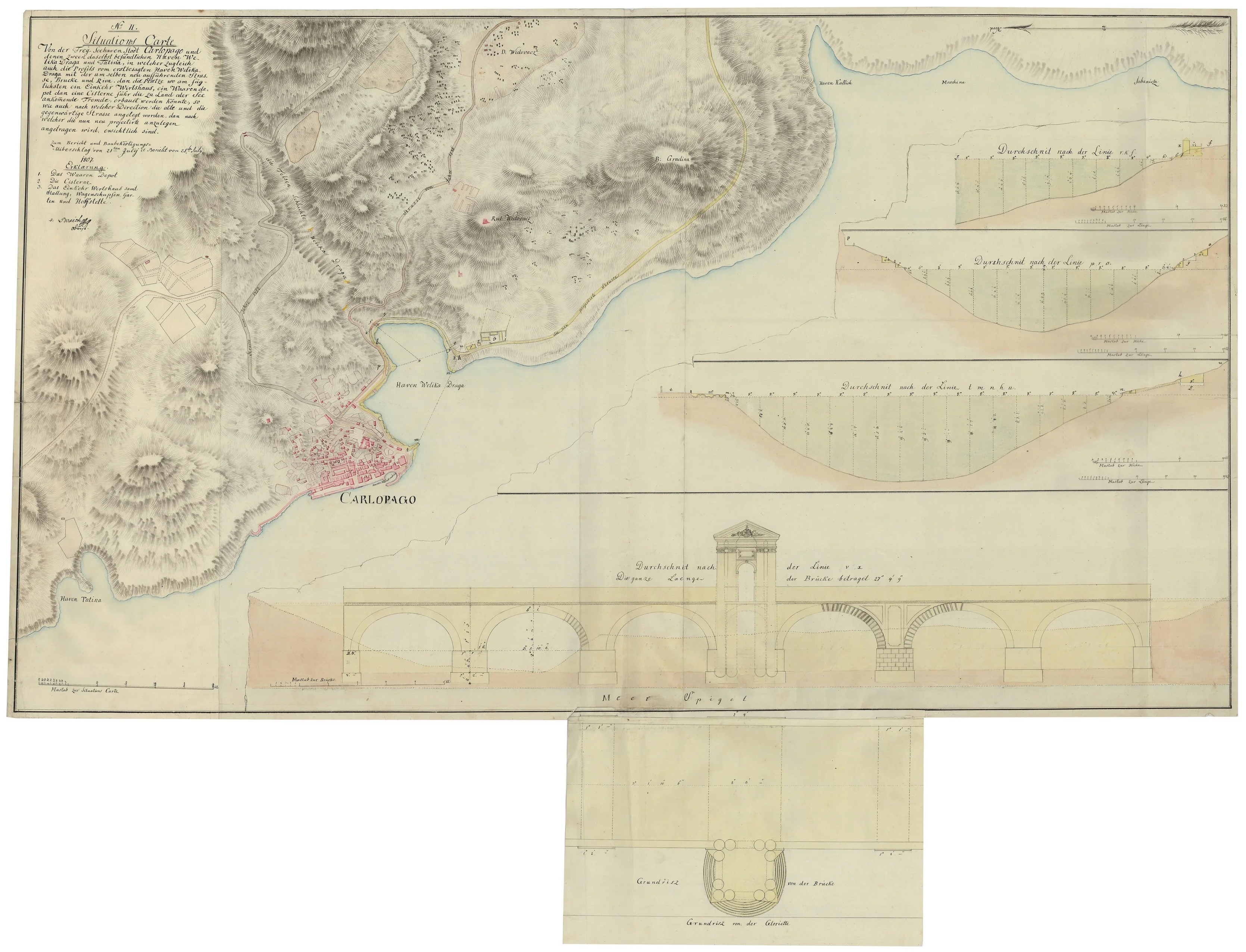
The Unbuilt Viaduct and the Harbours of Velika Draga and Tatinja
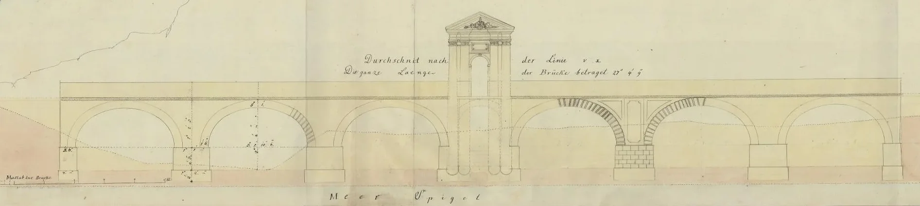
The central feature of the plan is a monumental stone bridge (viaduct) with a decorative tower. It was designed to span the deep ravine above the bay, avoiding the steep slopes so that the main road towards Zadar could follow a faster and more level course.
The project did not end with the bridge. Velika Draga Bay itself was intended to become a remarkable feat of engineering for its time.
Survey Plan of the Surroundings of Karlobag (Carlopago), 1807
This historic document presents engineering proposals for a new main road intended to improve the connection between Karlobag and Gospić. Alongside a detailed rendering of the coastal topography, the map includes precise terrain profiles and an architectural design for a monumental arched bridge, reflecting the strategic importance of this route to trade and communication between the coast and the interior.
Source: Austrian State Archives, Vienna.
Just as Karlobag appeared poised to become a more important transport hub in this part of Europe, political circumstances altered the course of its development. In 1809 the town came under French rule and was incorporated into the Illyrian Provinces. Wartime conditions halted part of the planned programme, while resources were redirected towards military needs.
The magnificent bridge shown on the drawing was never built. Although the main road was redirected towards Zadar and later completed, it was realised in a more modest form, following the coastline rather than crossing it on grand arches. The drawing remains a unique witness to a moment when Karlobag was intended to receive one of the region’s most remarkable road structures—a vision interrupted by the upheavals of empire and war.
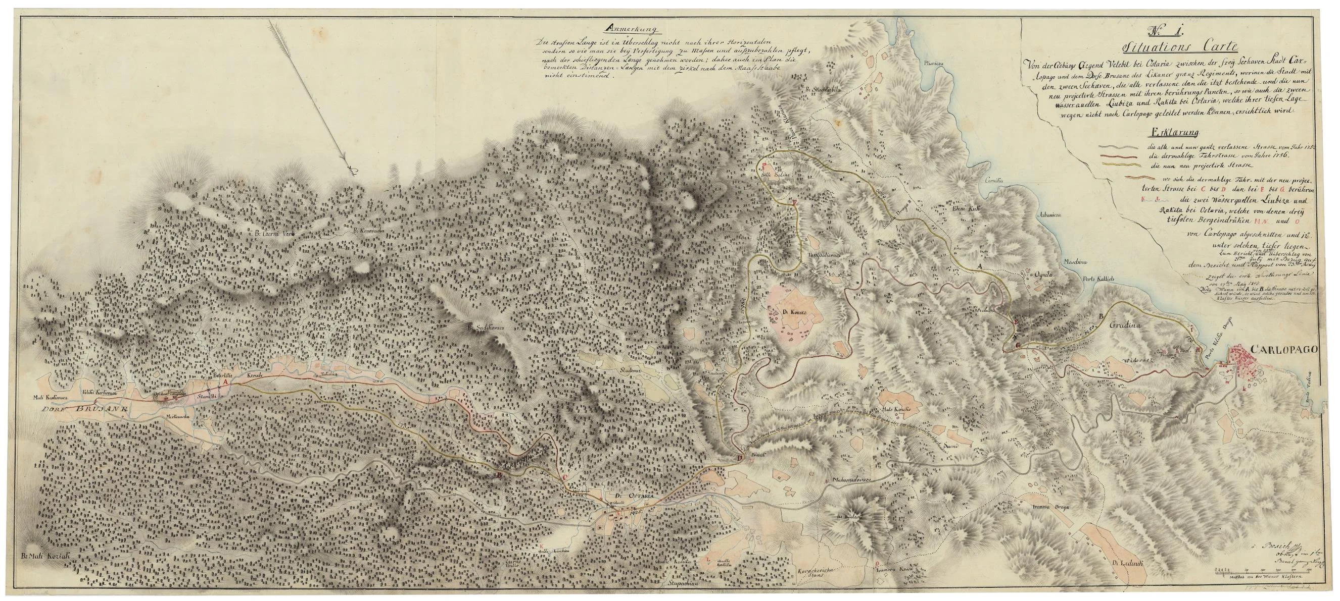
Survey Plan of the New Road from Karlobag (Carlopago) to Gospić, 1807
This detailed survey plan (Situations Carte) offers a rare view of the full scale of an engineering project intended to transform Karlobag and Lika. Unlike partial sketches, it follows the new road in its complete winding course, from the seashore to the mountain heights.
The map clearly shows how the new route, marked in yellow and red, transformed the logic of movement across the mountain. While the old road of 1752, shown in grey, remained trapped by severe gradients, the projected road of 1786 and its later improvements around 1802 used modern hairpin bends to negotiate the difficult slopes of Velebit.
Of particular interest on the right-hand side are the Ljubica and Rakita springs. Although close to Oštarije, the engineer notes that deep mountain depressions made it impossible to convey their water naturally to Karlobag. This explains why enormous cisterns had to be planned in the harbour itself, at Velika Draga Bay (point 2 on the profile), to support both the port and the road.
Source: Austrian State Archives, Vienna.
Repair and Enlargement of Karlobag’s Inner Harbour (1859)
A detailed study of the historic engineering project that transformed Karlobag’s harbour through the construction of a new mole and protective barriers. The documents bring together technical precision, surveying and a strategic response to the difficult conditions of navigation in the Velebit Channel during the mid-nineteenth century.
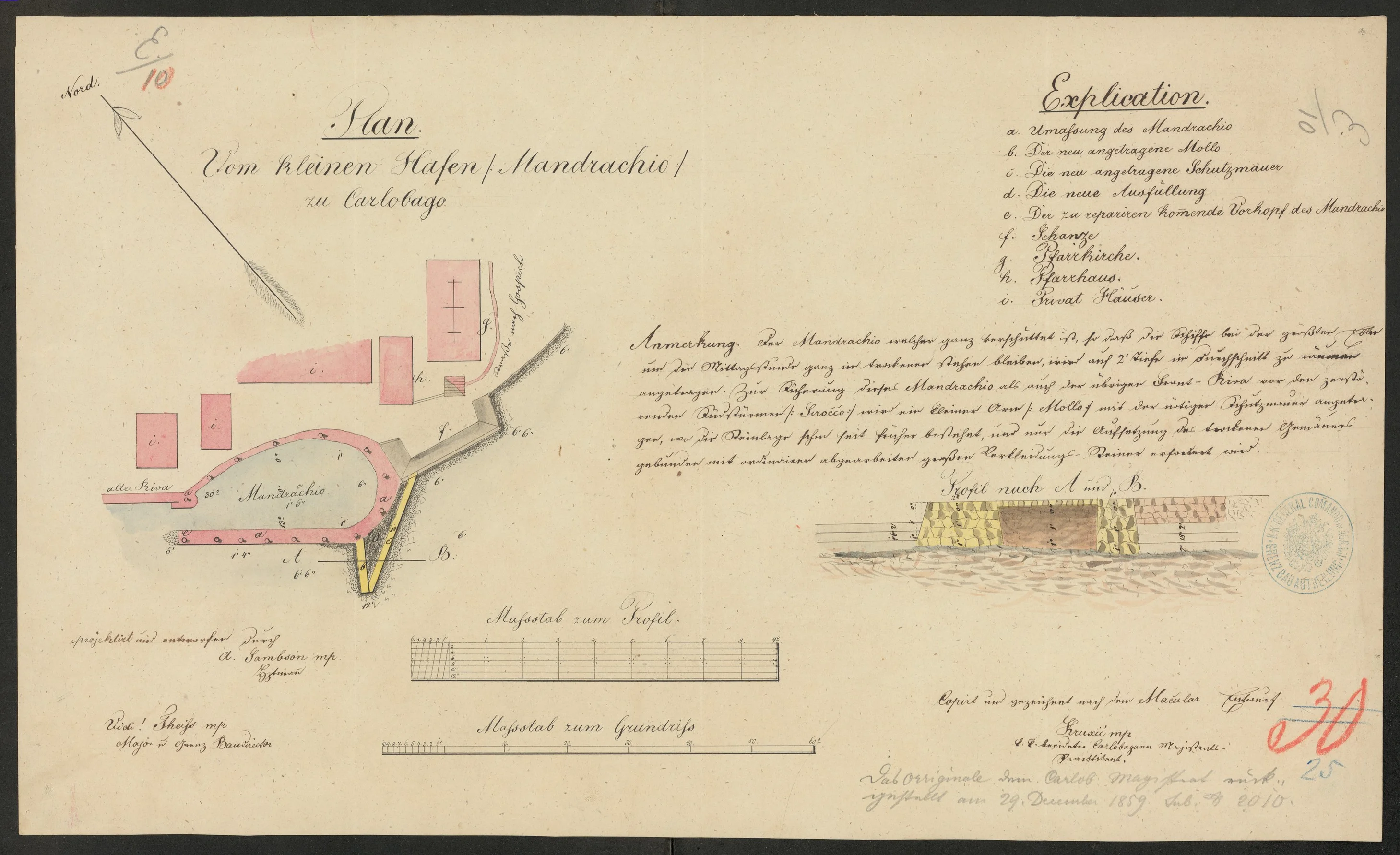
Repair and Enlargement of Karlobag’s Inner Harbour (1859)
This valuable engineering project of December 1859 sets out a detailed transformation of the small harbour, or “Mandrachio”. Far more than a preliminary sketch, it addresses one of Karlobag’s most serious maritime problems: the harbour’s exposure to the destructive force of the southerly Sirocco.
The planned works are clearly visible: a new mole, marked b, and a massive protective wall, marked c and shown in yellow. These were not decorative additions but essential defences intended to create a sheltered anchorage for vessels that had previously remained exposed and vulnerable in the old harbour basin.
The construction sections (Profil nach A und B) are especially valuable, demonstrating the high level of nineteenth-century engineering practice. Precise dimensions and the signatures of the frontier building authorities reveal how engineers responded to the difficult conditions of the Velebit Channel, transforming the inner harbour into a safer centre of maritime traffic and the working heart of Karlobag’s waterfront.
Source: Croatian State Archives (HDA), Zagreb, HR-HDA-905, Architectural Drawings, 1663–1990, XXVI.1.
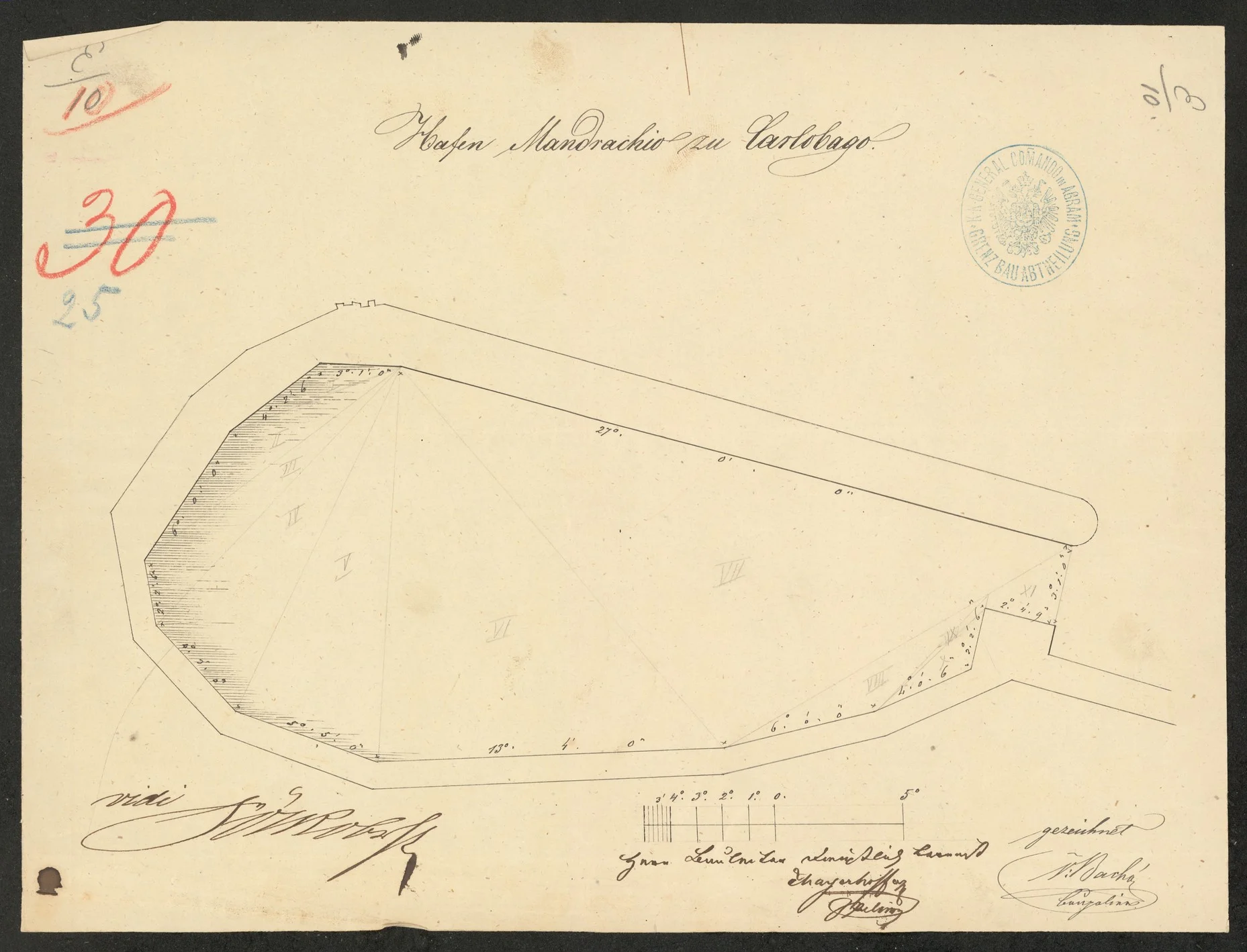
Geometric Basis of the Project: Plan of the Inner Harbour (HDA-0003)
This document forms the second part of the complete 1859 engineering project. While the first sheet combines written explanations with technical profiles, this ground plan (*Grundriss*) provides the precise geometric basis of the work. The harbour is divided into eight technical sections, numbered I–VIII, enabling builders to transfer the measurements accurately to the site.
The drawing represents engineering documentation of a high order and was certified by senior officials responsible for construction in the Military Frontier. Several important signatures and endorsements remain visible on the sheet:
- Designer: The plan was designed and drawn by A. Sambson.
- Chief supervision and approval: The project was approved and signed by Preiss, Major and Frontier Building Director (*Major & Grenz Baudirector*).
- Technical draughtsman: The copy and its technical precision were the work of Frnuzic, Imperial-Royal sworn building officer of the Karlobag magistracy.
The plan is more than a technical base drawing: it is evidence of the high level of planning and responsibility with which the authorities approached the safety of maritime traffic and the local community of Karlobag.
Source: Croatian State Archives (HDA), Zagreb, HR-HDA-905, Architectural Drawings, 1663–1990, XXVI.1.
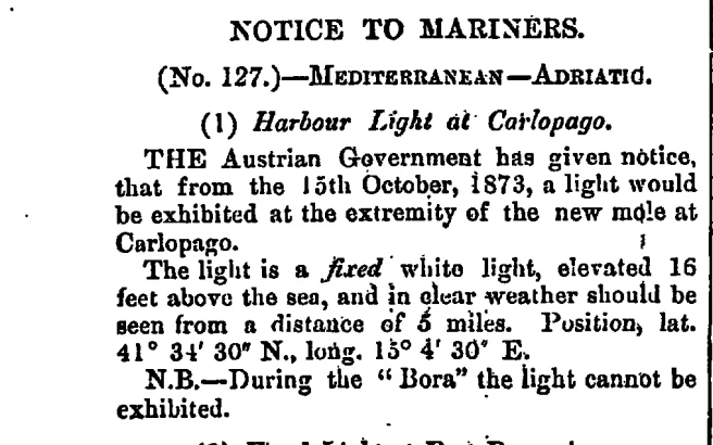
Source: The London Gazette, 12 December 1873, no. 24039.