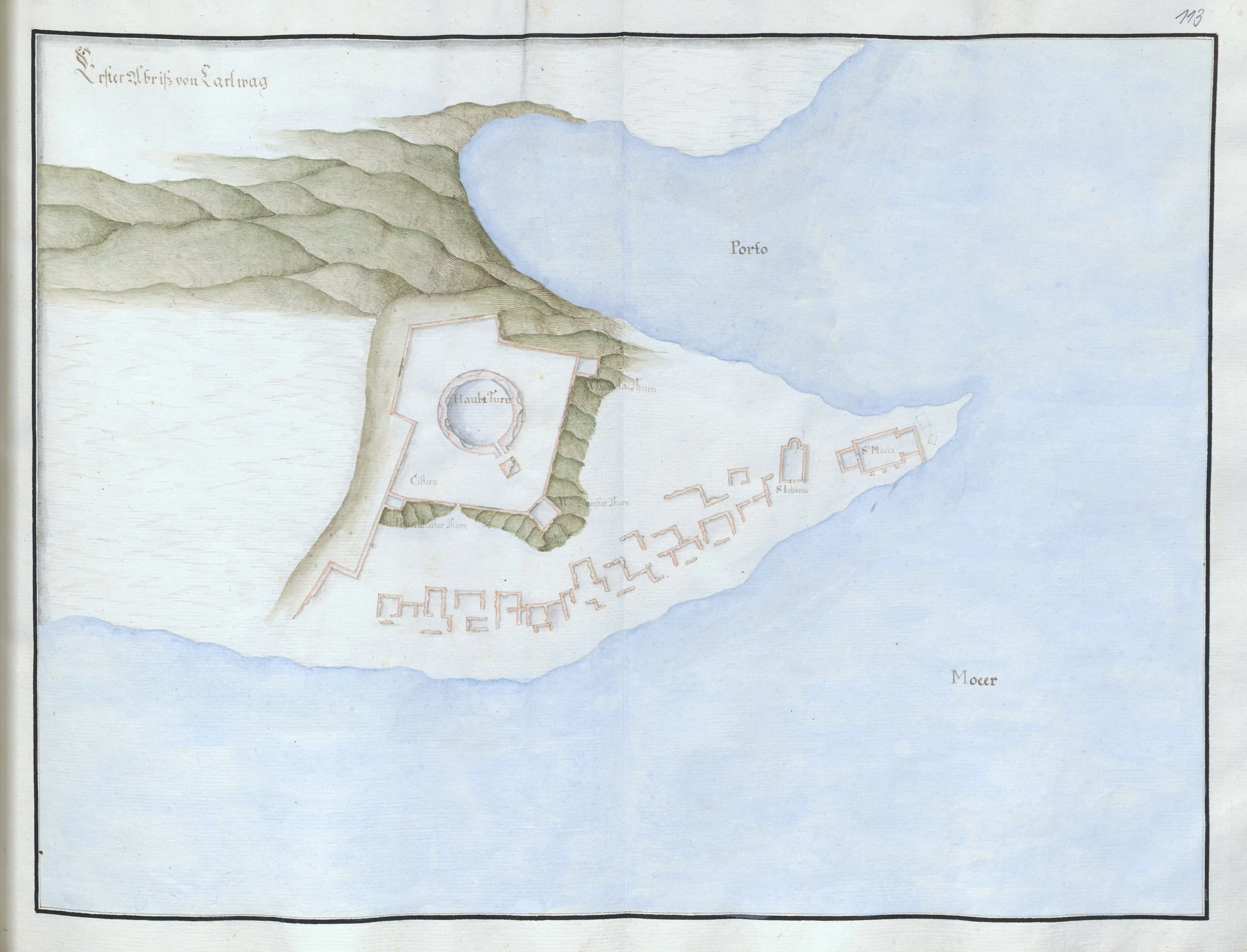
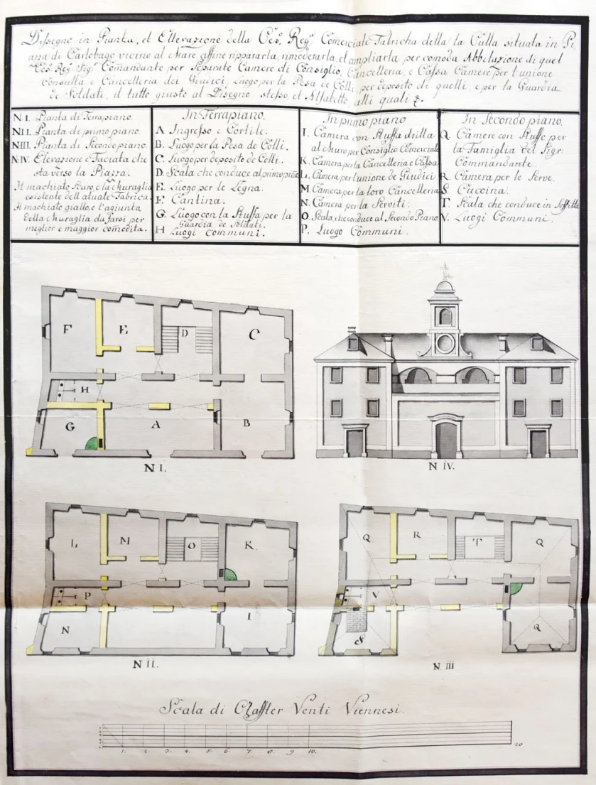
The ground plan of the horse stable and quarantine for people arriving in the town, marked with the letters E and F, along with the displayed elevation (facade) and cross-section, illustrates a key facility for accommodating travelers entering the town and their horses.
The large stable for accommodating horses and caravans was intended to be built at the entrance to the town from the north side (in the area of today's chapel above Fortica). It was planned to be an elongated single-story building divided into six larger stable compartments covered with a gable roof with skylights. On the south side of the facility, there were three rooms for afflicted travelers.
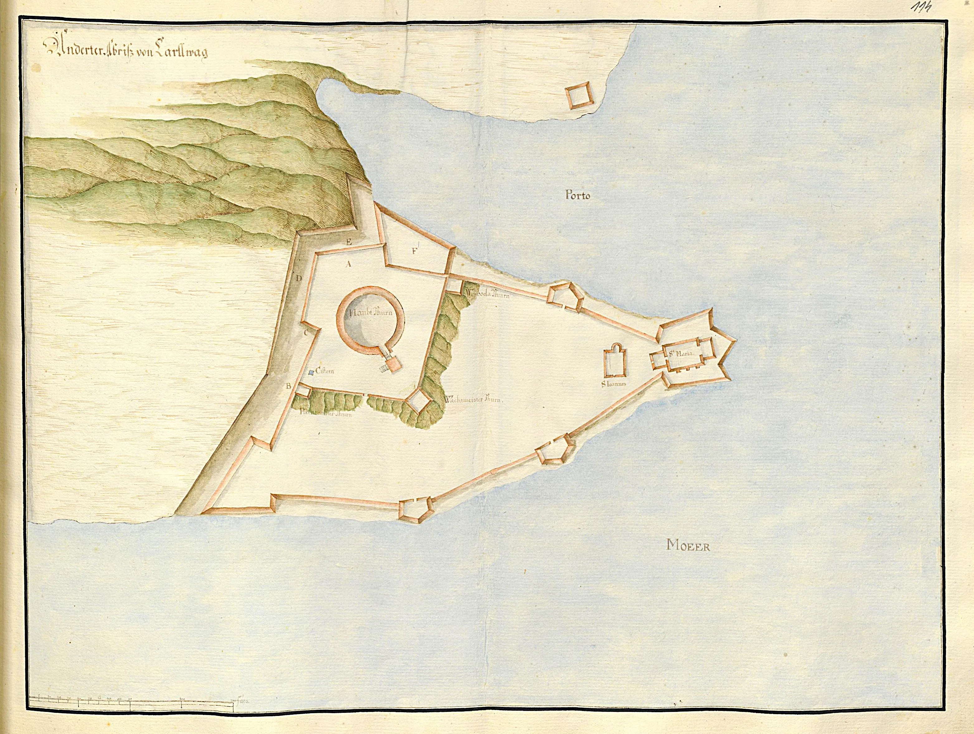
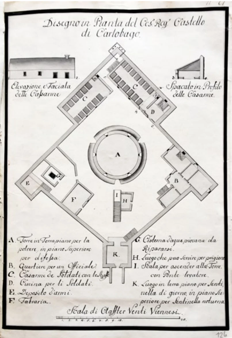
Antonio Michelazzi, 1757. – It was the year 1757 when the renowned imperial engineer Antonio Michelazzi completed this precise drawing of the Imperial–Royal fortress in Karlobag. This parchment is not merely a depiction of a fortification, but a vision of order. Michelazzi meticulously drew the ground plan of the main fortress and its accompanying structures. Soldiers’ barracks (Casarme de Soldati), the kitchen (Cucina per li Soldati), the weapons depot (Deposito d'armi), and the main powder tower (Torre in Terraplano) – everything was there, organized within a rhomboid defensive wall.
Through sections (Spacato in Profilo) and elevations (Elevazione e Facciata), Michelazzi sent a clear message to Vienna: the Karlobag Fortress would become an impregnable bastion against the fierce Velebit bora wind, a symbol of Habsburg power on the Adriatic.
Document sourced from the collection of the Croatian State Archives (HDA) in Zagreb, intended exclusively for educational and illustrative purposes.
Translation of the text from the drawing:
- Imperial–Royal Fortress in Karlobag (Ces: Reg: Castello di Carlobago).
Left side:
- A. Tower – ground floor for gunpowder storage, upper floor for defense.
- B. Quarters for one officer.
- C. Soldiers’ barracks with their own cisterns.
- D. Kitchen for the soldiers.
- E. Weapons depot.
- F. Forge.
Right side:
- G. Rainwater cistern under repair.
- H. Room that could serve as a prison.
- I. Staircase leading up to the Tower with a drawbridge.
- K. Room on the ground floor for the day guard, and on the upper floor for the night guard.
Scale of twenty Viennese fathoms.
Reconstruction of the Fortica in Karlobag (1757)
Michelazzi designed and restored the neglected Karlobag castle on the hill, producing a plan of the existing condition with the addition of a barracks on the northern side of the complex at a cost of 1,000 florins. Around the older cylindrical tower at the heart of the fortress, he built a castle resembling a rotated square with rectangular towers at the corners. The entrance was on the southern side, through a tower that housed the day guard on the ground floor and the night guard on the upper floor. The ground floor of the central tower contained the powder magazine, while the upper floor was intended for defense and accessed from the courtyard via a stone staircase with a drawbridge. Adjacent to the staircase, Michelazzi proposed a prison function. The eastern part of the courtyard was occupied by a two-storey building with five rooms for an officer, while the western part contained a forge, a cistern, and an external staircase leading alongside a corner tower that housed the armory. Finally, in the northern corner of the castle, Michelazzi added two separate single-storey buildings leaning against the wall, serving as heated sleeping quarters for soldiers; in the northeastern one, he also placed a kitchen with a fireplace.
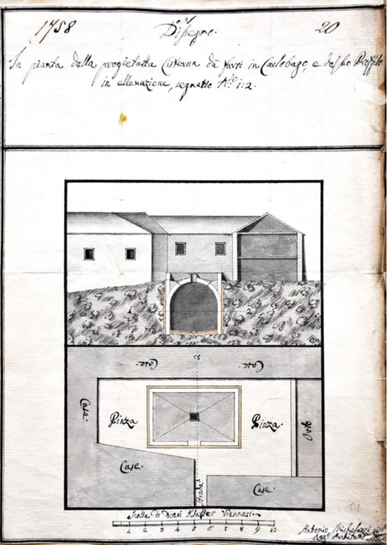
Antonio Michelazzi, 1757. – Ground plan of the designed cistern and its sectional view.
Document sourced from the collection of the Croatian State Archives (HDA) in Zagreb, intended exclusively for educational and illustrative purposes.
The Karlobag Water Supply Solution: Michelazzi’s Engineering Intervention (1756)
In 1756, Karlobag faced an acute shortage of drinking water. Due to the critical situation, engineer Michelazzi arrived in the town on August 30 by order of the imperial commander, with a key task: to find a location for a new, massive cistern and to design a solution for repairing the existing water infrastructure.
Project of the New Cistern
For the new construction, Michelazzi chose an abandoned square in the town center, measuring 12 × 6 fathoms (surrounded by ruined houses). His plan included a cistern measuring 5 × 3 × 3 fathoms, capable of holding more than 5,000 barrels of water. Although he estimated that even this capacity would not be sufficient for all the inhabitants’ needs, the construction of this cistern was valued at a significant 2,000 florins.
Reconstruction of the Old Cistern and Sanitation
At the same time, Michelazzi emphasized the necessity of repairing and sanitizing the old town cistern (probably at the northern end of the main square). The main problems were stagnant water and impurities in the channels. The renovation plan included draining the stagnant water, removing debris from the old channels, reshaping the cistern into a regular square form, insulating the walls with lime and clay, repairing the hanging gutters from roofs used to collect rainwater, and modifying the pump area.
The cost of repairing and modernizing the old cistern was estimated at an additional 1,000 florins.
Michelazzi formalized his detailed report the following year, referring to findings from August, by submitting a signed drawing of his cistern, including the ground plan and section, thus bringing the Karlobag water supply project into the consideration phase.
Competition and Financial Cuts: Rejection of Michelazzi’s Projects
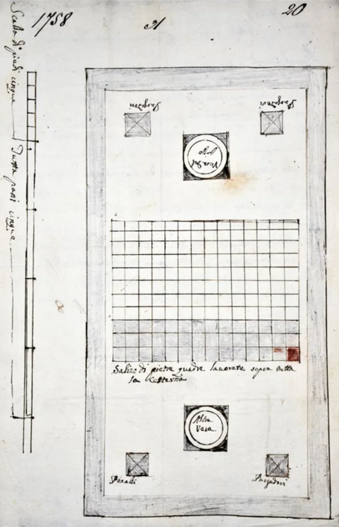
Roko Stuparić from Veli Lošinj, 1757 – Ground plan of the proposed new cistern
Document sourced from the collection of the Croatian State Archives (HDA) in Zagreb, intended exclusively for educational and illustrative purposes.
Although engineer Michelazzi had detailed plans for the Karlobag castle and water supply, his projects encountered strong resistance due to high costs and the reservations of the local administration.
To avoid Michelazzi’s high expenses, the local authorities invited another expert in 1757: the builder and master mason Roko Stuparić from Veli Lošinj, who submitted his own design and cost estimate for a new cistern.
Comparison of Stuparić’s proposal: a cistern 30 feet long, 15 feet wide, and 12 feet high, with a capacity of approximately 3,600 barrels of water. The cost was estimated at 1,611 ducats. In the cost breakdown, he highlighted two large carved cistern crowns and square stone slabs for paving its terrace.
The local official Mateo Diminić from Karlobag openly supported Stuparić in his report from March 1758. He emphasized him as an expert who had built cisterns throughout Dalmatia, noting that Stuparić had already constructed one cistern on the main town square and three more within the settlement. Due to this reputation, Diminić believed that Stuparić should also be entrusted with the construction of the new cistern.
It is believed that Stuparić’s project was carried out, as the cistern with stone paving and two carved crowns has been preserved in today’s Ivana Vrbana Street, near the town square.
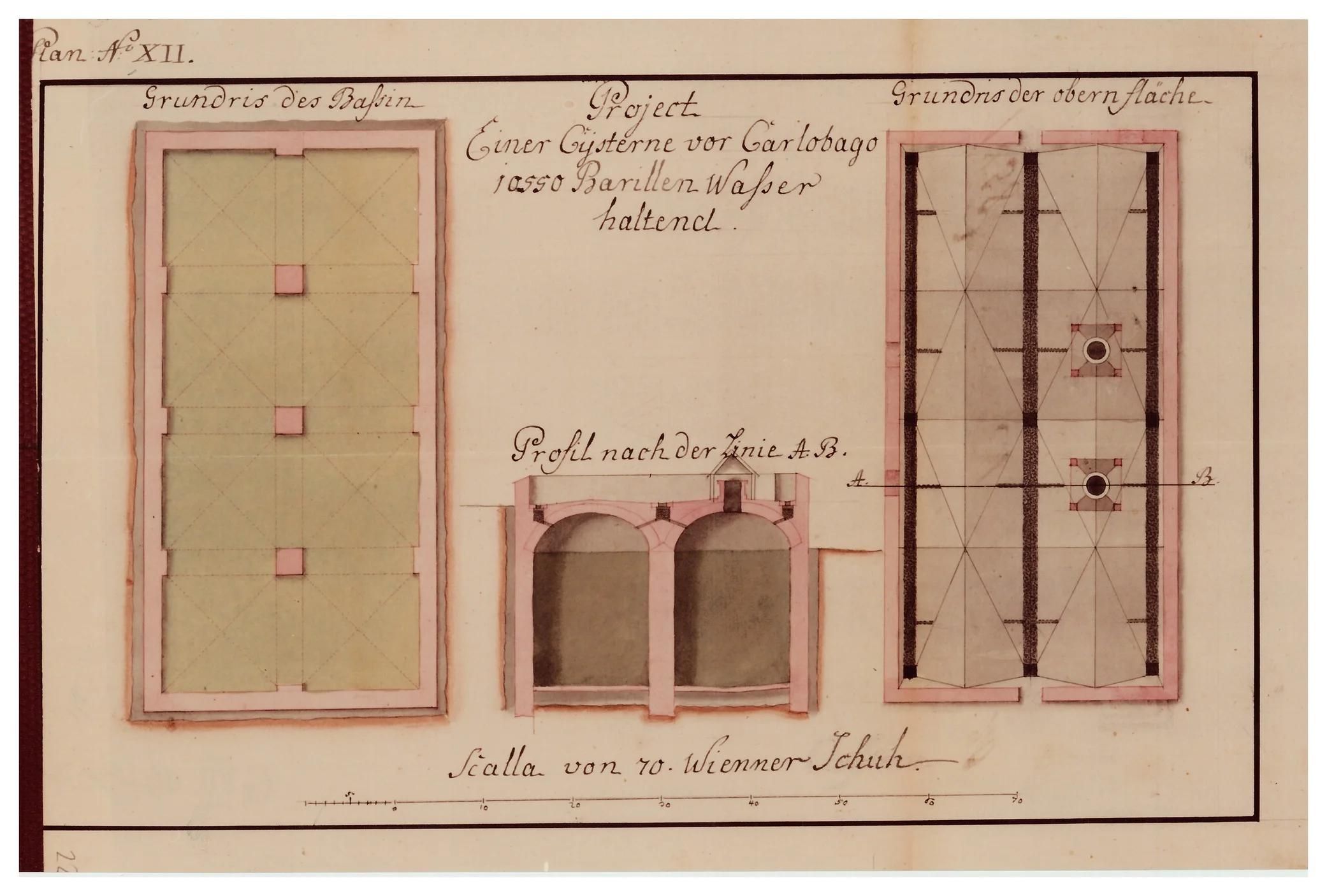
Engineering Solution: Water Cistern Project (1758)
This 1758 cistern project testifies to the immense importance of water supply for the survival and development of Karlobag. The development path of this project is a clear example of state resource optimization: after Antonio Michelazzi created the initial vision in 1756, it became clear that the financial requirements of that plan were too high for the time. Therefore, Roko Stuparić, known for his more economical solutions, was engaged in 1757 to adapt the project to realistic possibilities. The result of this process is this 1758 design, which represents a superior compromise between necessary functionality and the strict budgetary discipline of the Viennese court.
The design displays a sophisticated construction: "Grundris des Bassin" (floor plan of the basin), "Grundris der obern Fläche" (floor plan of the upper surface), and "Profil nach der Linie A.B." (cross-section). A system with two vaulted sections divided by support pillars allowed for the secure storage of 10,550 barrels of water. Such a construction, buried in the ground with precise vaults, demonstrates the engineering knowledge required to secure water supplies in a karst terrain where every spring was a strategic point.
This document is not merely a technical drawing; it is proof of the "struggle against nature." At a time when Karlobag was becoming a trade and military hub, the issue of drinking water became a matter of state security. This cistern project therefore represents fundamental infrastructure without which all other construction endeavors, such as the barracks in Culla or road construction, would have been doomed to failure.
This cistern project represents a fascinating document that goes beyond mere water storage, revealing the high construction standards the Monarchy imposed in its coastal outposts. Through carefully drawn profiles and floor plans, engineers documented every element of the construction—from foundations to the cover and the water intake system—aware that the town's stability depended on the meticulous planning of every centimeter of this system.
Ultimately, this document testifies to the vision of Karlobag as a town that relies not on luck, but on superior engineering. The precision with which the capacity of 10,550 barrels of water was planned confirms that this was a project of supreme importance for the daily life of the garrison and the citizens. Through this display, we gain insight into a time when every "Viennese klafter" and every drop of water was planned with incredible precision, making this plan one of the most important witnesses to the history of Lika and the coast.
The document was retrieved from the collection of the Austrian State Archives in Vienna, exclusively for educational and illustrative purposes.
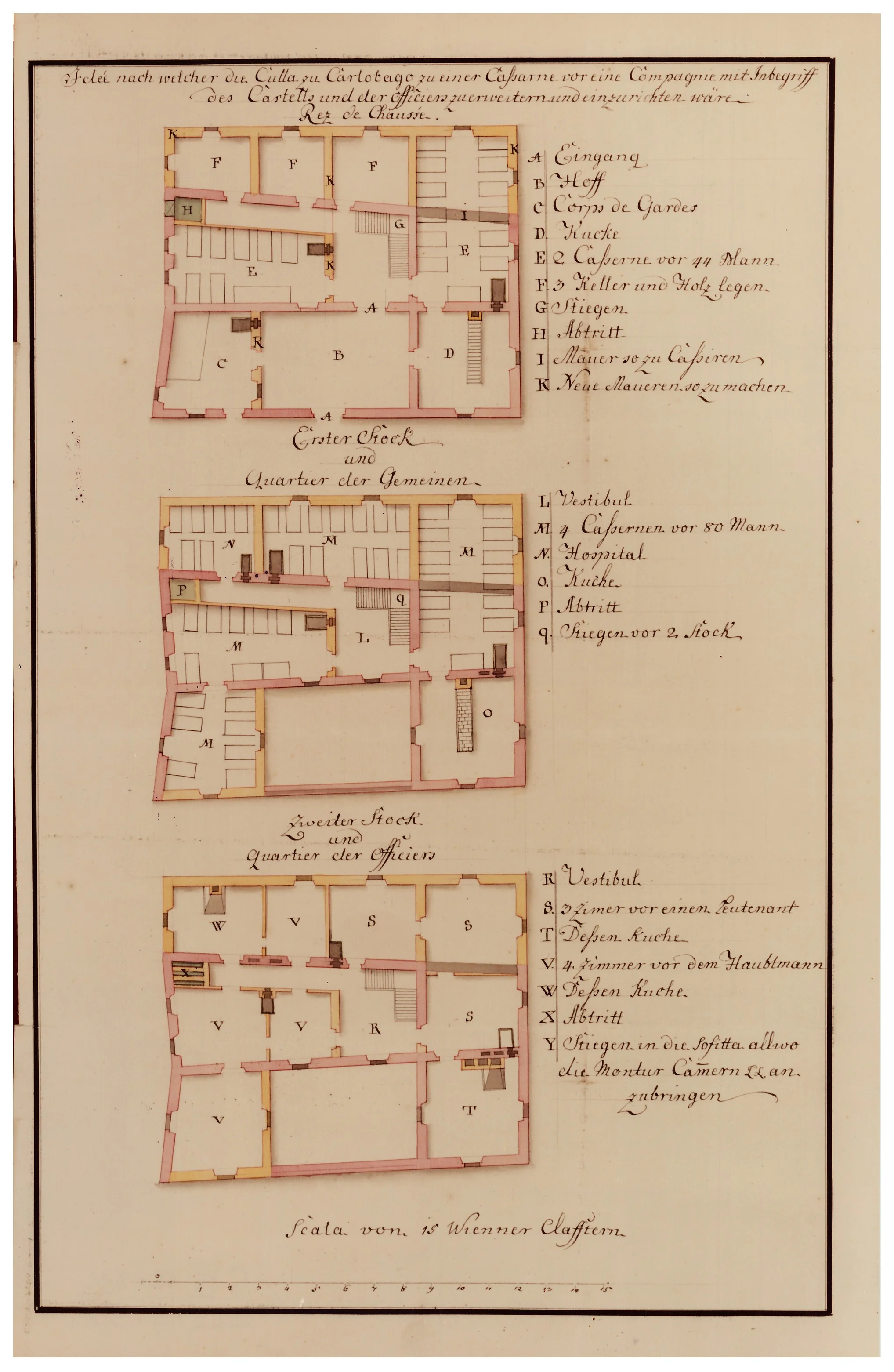
Military Architecture: Adaptation of the Culla Building into Barracks (1759)
This 1759 design is a key document in the transformation of Karlobag from a trade center into an important military-administrative hub of the Monarchy. While the 1757 design reveals the initial vision of Antonio Michelazzi, this 1759 plan (Idee nach welcher die Culla zu Carlobago zu einer Casarne... zu erweitern und einzurichten wäre) vividly displays the concrete engineering interventions required to convert the building into functional barracks to house an entire company. The document is a testament to a time when every square meter of space—from ground-floor warehouses to upper officers' quarters—had to be reorganized to meet strict military protocols.
The plan meticulously records the soldier accommodation system (categories of 44 to 80 men), rooms for officers (lieutenants and captains), as well as necessary hygienic and logistical facilities such as a hospital, kitchens, and sanitary facilities. Particularly interesting are the markings on the plan (K - Neue Maueren), which clearly show where engineers planned the demolition of existing walls and the construction of new partition walls, providing us with direct insight into the construction logic of the time. This adaptation was not merely cosmetic; it was a complete change in the building's purpose that defined Karlobag as a fortified stronghold on the Velebit.
This document is essentially a "witness to the militarization" of space. It was exactly these types of plans, which precisely defined where soldiers would sleep and where officers would stay, that created the conditions for a stable stay of the garrison that controlled the routes toward the interior. On this plan, we see Culla at the moment its character permanently changes, setting the foundations for an urban structure that would later, along with road construction, develop throughout the 18th century.
This conversion design represents a fascinating document that goes beyond mere room outlining, revealing the complex system of military logistics needed for life and work in the border town of Karlobag. The document serves as a detailed display of the engineering standards the Viennese court implemented in its coastal outposts, where every interior space—from armories to officer quarters—was planned with maximum precision.
See the original 1757 Culla plan for a comparison with this later military conversion.
Barracks Space Organization (1759):
- Ground Floor (Quartier der Gemeinen): Entrance, courtyard, space for 44 soldiers (E), cellars and wood storage (F), staircases (G), and sanitary facilities (H).
- First Floor (Quartier der Gemeinen): Rooms for 80 soldiers (M), hospital (N), kitchen (O), and sanitary facilities (P).
- Second Floor (Quartier der Officiers): Officer quarters (S, V), kitchens (T, W), sanitary facilities (X), and a staircase leading to the attic (Y) intended for military equipment storage (Montur Camern).
Ultimately, this document testifies to the vision of Karlobag as a modern military hub. The clarity of the drawing and the precision of the indications for new walls (K - "Neue Maueren") give the design historical weight, confirming that this was a project of supreme state importance that permanently changed the character of the Culla building.
The document was retrieved from the collection of the Austrian State Archives in Vienna, exclusively for educational and illustrative purposes.
Architectural Vision: Parish Church of St. Carlo Borromeo (1765)
This 1765 architectural design is an invaluable document of the time when Karlobag was strategically shaped as an important administrative and religious center of the Monarchy. Although the design uses the name "Parochiale Chiesa," it actually testifies to the engineering precision with which the construction of the most important building in town was planned. The document from the Viennese archives confirms that the church was conceived not only as a spiritual space but as a representative building aligned with the high standards of Baroque construction of that era. We can almost certainly say that this project is a direct continuation of Antonio Michelazzi's vision and his 1757 Culla building designs, confirming the continuity of a high architectural school in the planning of Karlobag.
Unlike improvised sacral buildings, this plan follows the strict logic of Baroque symmetry and functionality. The design precisely records the floor plan system (A), the church nave (B), and the sanctuary (C), but also provides technical instructions to construction contractors, such as those regarding the change of color of certain decorative elements. That meticulous communication between designers and builders on the field was crucial for the realization of a project that was, by its appearance, meant to symbolize the stability and progress of Karlobag at the time.
This document is essentially the "architectural signature" of an era. It was precisely these types of precise designs—from the position of the organ to the elevation sections—that created the foundations for construction that was meant to withstand the test of time and the harsh Velebit climate. On this plan, we see the church at the moment Karlobag transforms into a planned urban settlement, just before further development of infrastructure and road routes would additionally solidify its position on the map of the Monarchy.
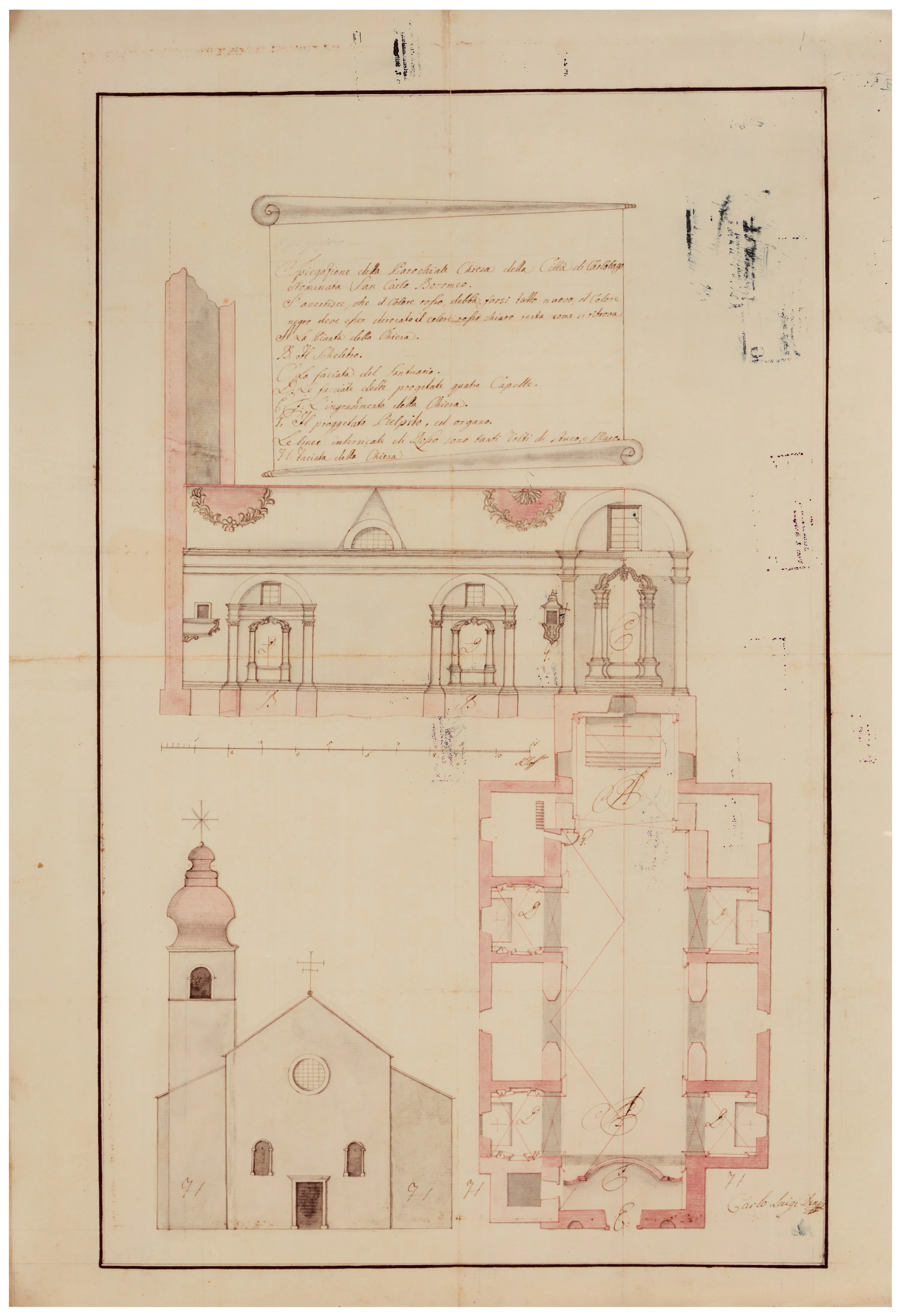
This architectural design represents a fascinating document that goes beyond mere wall outlining, revealing the complex system of urban core planning. Although the primary focus is on the Parish Church of St. Carlo Borromeo itself, the document also serves as a detailed display of the engineering and aesthetic standards the Viennese court imposed in its border areas. Through carefully drawn legends and instructions, the engineers of that time documented every segment of the interior, aware that every church serves as a visual anchor and social center around which the population gathers.
Ultimately, this document testifies to the vision of Karlobag as a modern center whose urban rise depended on the synergy of superior design and execution. The clarity of the drawing and the precision of the notes give the design a human dimension, confirming that this was a project of supreme state importance. Through this display of the floor plan, cross-section, and visual identity of the church, we obtain a complete picture of a time when every detail—from the color of elements to the position of the altar—was planned with incredible meticulousness, making this plan one of the most important witnesses to the history of Lika and the coast.
The document was retrieved from the collection of the Austrian State Archives in Vienna, exclusively for educational and illustrative purposes.
Between the Charles Road (Carolina) and the Theresiana: The Restoration of the Old Road (1770)
This geographical map from 1770 represents a precious document of a time when the old route from 1752 was being adapted to the new economic demands of the Monarchy. Although the term "new commercial road" (neue Commercial-Strasse) is used on the map, it actually testifies to the efforts to organize, widen, and better connect the existing, extremely difficult, and steep Carolina (built in 1752) with the administrative center in Gospić.
Unlike the later Vukasović road, this plan still follows the "old logic" of conquering Velebit. The route struggles with peaks such as Belebiza Glavize and Eedezika, and its turns are sharper and more direct, which at the time represented a massive effort for any commercial horse-drawn team. The map precisely records the system of military guardhouses and settlements, as well as water sources like those near Oštarije, which were crucial for the survival of people and livestock on this harsh journey.
This document is essentially an "admission of the inadequacy" of the old route. It was the flaws of this road, which were already evident by 1770—from excessive steepness to its being unsustainable during winter months—that created the pressure on the Viennese court which, a decade later, would result in the construction of the completely new, modern Theresiana. On this map, we see Lika and Karlobag at the moment the old road reached its limits, just before the engineering genius of Filip Vukasović would forever change the way we cross Velebit.
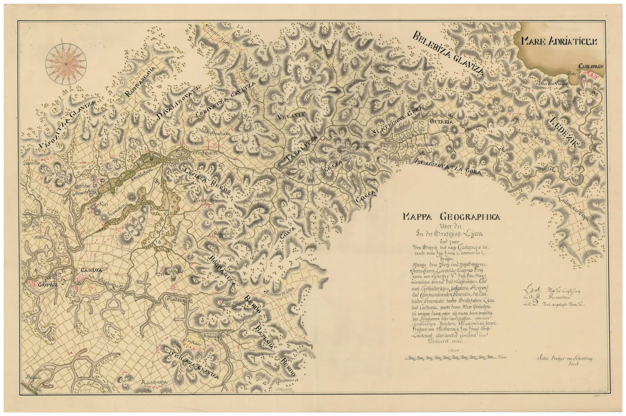
This geographical map represents a fascinating document that goes beyond mere road mapping, revealing the complex system of the entire infrastructure necessary for life and work in the Velebit karst. While its primary focus is on the new Imperial-Royal commercial road connecting Gospić to Karlobag, the map simultaneously serves as a detailed plan for water supply solutions, without which any traffic over the mountain would be unsustainable. Through carefully drawn legends, the engineers of that time documented the positions of reservoirs and waterworks, aware that every commercial team and every traveler depended on these critical points in a waterless environment.
Ultimately, this document testifies to the vision of Karlobag as a modern commercial center whose rise depended on the synergy of superior engineering and logistics. The dedication to General Scherzer by Lieutenant Colonel Mitterssky gives the map a human dimension, confirming that this was a project of top national importance. Through this depiction of the road, water, and strategic positions, we get a complete picture of an era in which every kilometer of road and every drop of water was planned with incredible meticulousness, making this plan one of the most important witnesses to the history of Lika and the coast.
The document is taken from the collection of the Austrian State Archives in Vienna, exclusively for educational and illustrative purposes.
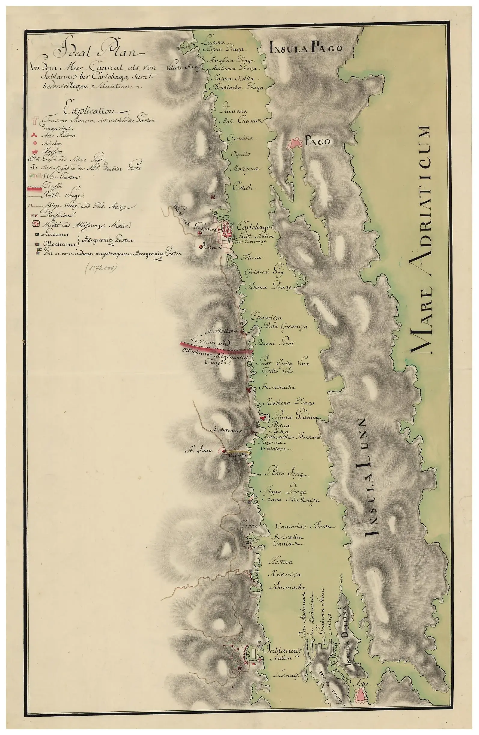
A Vision in Stone: The Dream of the Sub-Velebit Coast (1773)
The year is 1773, and the bura wind from Velebit howls as only it can, sweeping away everything in its path as it descends toward the sea. In the lee of a stone house, by the flickering light of a candle, an imperial engineer carefully draws lines on paper. His hand is not just tracing a coastline; he is sketching the future. Before him stretches the wild, rugged landscape from Jablanac to Karlobag—a place where the mountain plunges directly into the depths of the sea—which he labels in his draft as the "Ideal Plan."
At that time, this part of the Adriatic coast was the edge of the world, a dangerous and unpredictable frontier of a vast empire. While courtiers in distant Vienna strolled through manicured gardens, the people of Lika and Otočac—hardened frontiersmen whose names are proudly recorded in this plan's legend—fought a daily battle against stone and wind. The engineer's task was nearly impossible: to find order in that chaos of rocks. He plots small harbors, shelters where ships could hide when the sea turns violent, and footpaths that he hopes will one day become wide roads smelling of salt, grain, and timber.
Every symbol on this map carries its own story. The red crosses of churches speak of sailors' prayers before setting sail, and the precisely drawn dry-stone walls tell of the persistence of peasants who reclaimed pieces of peace from the barren land, bit by bit. This "Ideal Plan" was, in fact, a dream of civilization in the midst of the wilderness. It was an attempt to tame Velebit and connect the Adriatic blue with the dark forests of the interior, turning remote coves into gateways to the world.
Today, more than two centuries later, that paper stands as a silent witness to a great ambition. It reminds us that every road we travel today and every port we sail into originates from someone's vision—from a time when someone, amidst the bare karst and under the strikes of the bura, believed that something lasting and beautiful could be created in this place. Looking at those old, elegant ink lines, we see not just a map, but the courage of a human to dream of progress where only stone and sea existed.
This historical document from 1773 represents a visionary "Ideal Plan" of the Adriatic coast between Jablanac and Karlobag. Created at the height of Habsburg efforts to tame the Velebit karst, it is not merely a geographical representation, but a strategic blueprint for connecting the interior with the sea.
The map precisely records the reality and future ambitions of the time: from safe harbors and shelters from the bura, to the border stations of the Lika and Otočac regiments, and the painstakingly built dry-stone walls and footpaths. Written in elegant calligraphy, it remains a lasting testament to a time when the future of modern trade and maritime affairs was being etched into harsh stone.
The document is taken from the collection of the Austrian State Archives in Vienna, exclusively for educational and illustrative purposes.
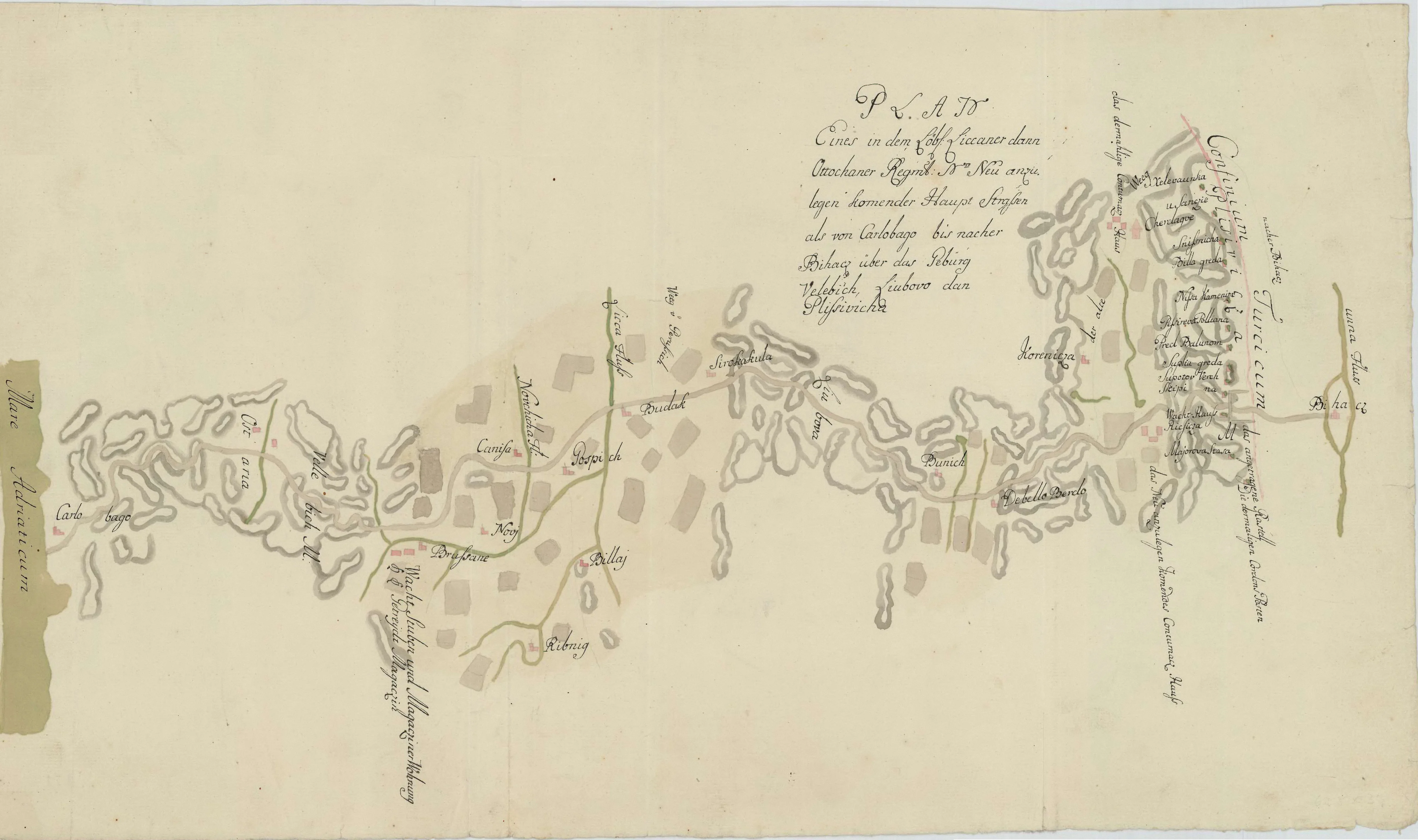
BETWEEN THE MOUNTAIN AND THE SEA: An Engineering Dream of Karlobag
The story begins in 1746, at a time when the Habsburg Monarchy made a bold decision: to connect the Adriatic coast directly with Bihać. This route was not merely a trade path; it was a military imperative that had to pierce through three massive natural barriers: the rugged peaks of Velebit, the Ljubovo plateau, and the Plješivica massif.
On the original handwritten drafts from that era, we see a path connecting the Adriatic with the fortresses on the "Turkish border" (Confinium Turcicum). It was an attempt to erase the isolation of Lika and place it at the very center of European communications. However, that early road was harsh, steep, and almost impassable for heavy wagons – the mountain was still stronger than man.
On these faded lines, three lifelines are drawn:
The Road of 1752
Marked as the "old road" (alte Straße), it followed steep, natural ravines. It was a struggle for bare survival on the karst, with inclines that horse-drawn teams could barely overcome.
The Theresiana of 1786
The work of the brilliant Filip Vukasović. Visible as the newest road of that time, it introduced serpentines and gentle slopes, bringing the first true accessibility to Velebit.
The New Projected Road
The most ambitious line on the map – a vision of a modern highway that was intended to extend towards Gospić.
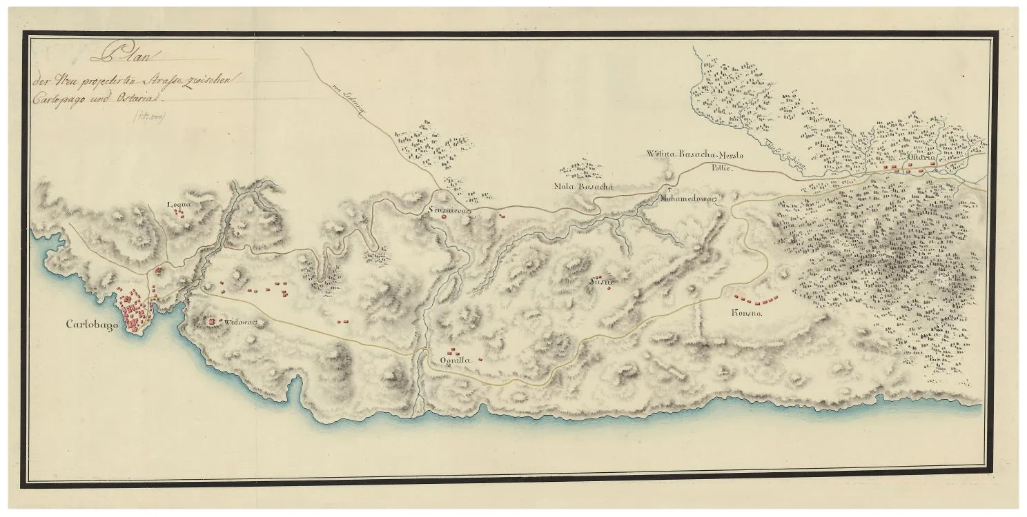
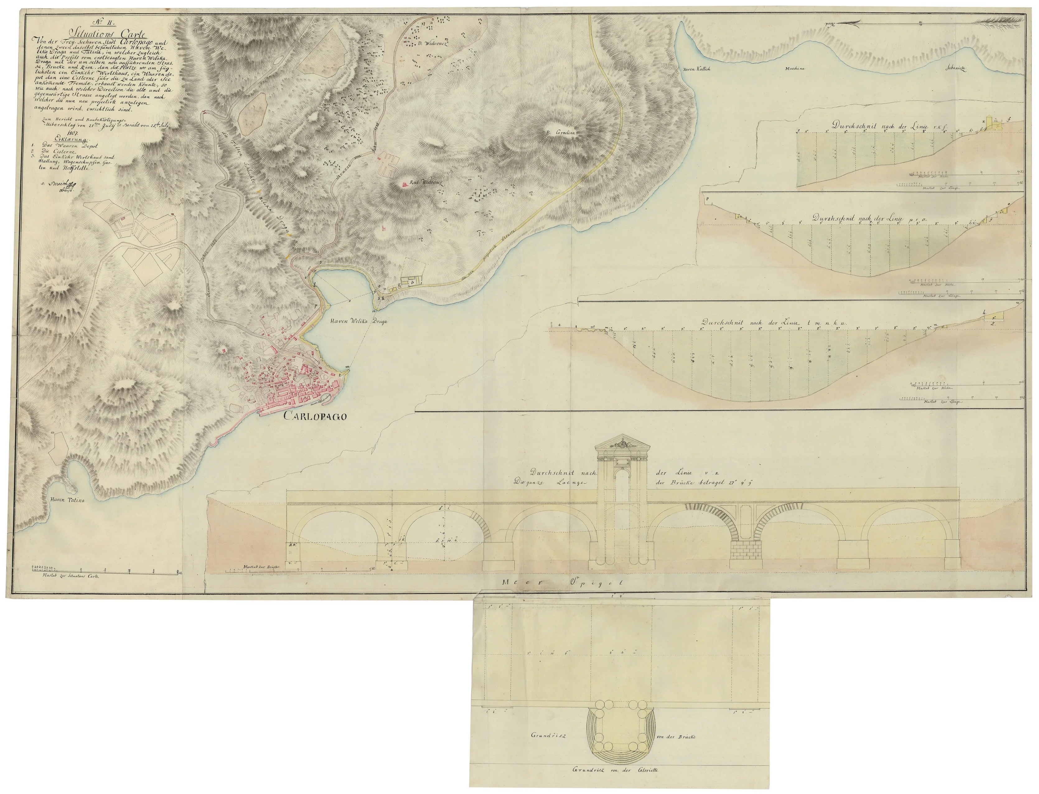
Situational draft of the new road from Karlobag (Carlopago) to Oštarije from 1786
This technical draft represents the pinnacle of planning for the new main road between Karlobag and Oštarije, documenting the moment when imperial engineering thought attempted to permanently overcome the harshness of the Velebit massif. Unlike earlier, steep paths that cut directly through the mountain, this plan shows a modern route that winds up the slopes, using wide serpentines and gentle inclines adapted for heavy commercial wagons. The meticulously drawn relief, which includes the massifs of Velika and Mala Basača and settlements like Vidovac and Konjsko, testifies to a deep understanding of the terrain and the desire to turn every natural obstacle into an engineering advantage.
The central part of the plan reveals an ambitious vision of connecting Lika with the sea coast, where the road stops being just a local path and becomes a strategic commercial lifeline. Special attention is paid to logistical details, such as the system for lowering materials into Velika Draga bay and solving the chronic lack of water by designing a system of cisterns. Every line on this map, from the precise sea level measurements to the plotted mountain springs that remained out of reach for the town, is part of a broader plan intended to transform Karlobag into the most modern port of the northern Adriatic and a key hub towards Zadar and the interior.
The document is taken from the collection of the Austrian State Archives in Vienna, exclusively for educational and illustrative purposes.
Situational layout of the Karlobag (Carlopago) area from 1807
This historical document displays engineering plans for the construction of a new main road aimed at providing a higher quality connection between Karlobag and Gospić. Along with a detailed depiction of the coastal topography, the map contains precise technical terrain profiles and an architectural blueprint of a monumental arched bridge, reflecting the strategic importance of this traffic route for the development of trade and communication between the coast and the rest of the country.
The document is taken from the collection of the Austrian State Archives in Vienna, exclusively for educational and illustrative purposes.
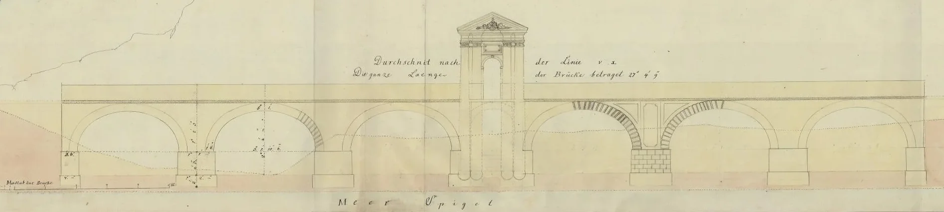
The Unrealized Viaduct and the Ports of Velika Draga and Tatinja
The central motif of the plan is a monumental stone bridge (viaduct) with an ornamental tower. It was designed to "fly over" the deep canyon above the bay, avoiding steep slopes so that the highway towards Zadar could maintain its speed and flatness.
The project did not stop at the bridge. Velika Draga Bay was meant to become a technological wonder of that era.
Just when it seemed that Karlobag would become a transport hub for this part of Europe, history changed direction. In 1809, Karlobag fell into the hands of Napoleon and became part of the Illyrian Provinces. The whirlwind of war halted the works, and funds were redirected to military campaigns.
The magnificent bridge from the blueprints was never built. Although the highway was redirected towards Zadar and completed later, it was realized in a humbler form, following the coastline instead of grandiose arches. This draft remains the sole witness to a time when Karlobag was supposed to be the home of one of the most beautiful road structures in this region – a dream interrupted by the rise and fall of an empire.
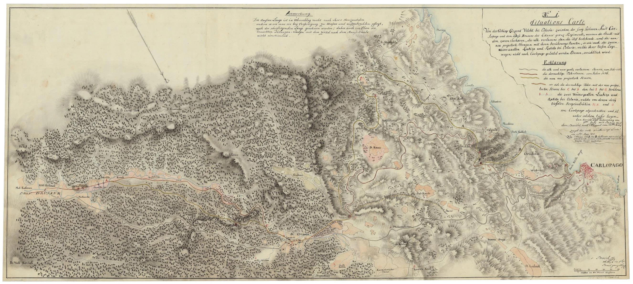
Situational draft of the new road from Karlobag (Carlopago) to Gospić from 1807
This detailed situational draft (Situations Carte) gives us a rare view of the full scope of the engineering undertaking that was supposed to change the face of Karlobag and Lika forever. Unlike partial sketches, this plan shows the new road in its full, winding form, from the seashore all the way to the mountain peaks.
On the map, it is clearly discernible how the new route (marked in yellow and red) brings a revolution in movement. While the old road from 1752 (gray line) was "trapped" by steep slopes, the new projected road from 1786 and its planned improvements around 1802 utilize modern serpentines to overcome the ruggedness of the Velebit.
An interesting detail on the right side of the plan are the Ljubica and Rakita springs. Although they were located near Oštarije, the engineer notes that due to deep mountain depressions, this water could never be naturally brought to Karlobag. This explains why it was necessary to design huge cisterns (point 2 on the profile) in the port itself, in Velika Draga bay, for the port and the road to survive.
The document is taken from the collection of the Austrian State Archives in Vienna, exclusively for educational and illustrative purposes.
Remediation and expansion of the "mandrač" (harbor basin) in Karlobag (1859)
A detailed analysis of a historical engineering project that documents the transformation of port infrastructure through the construction of a new pier and protective barriers. These documents represent a crucial blend of technical precision, geodetic survey, and a strategic response to the navigation challenges in the Velebit Channel during the mid-19th century.
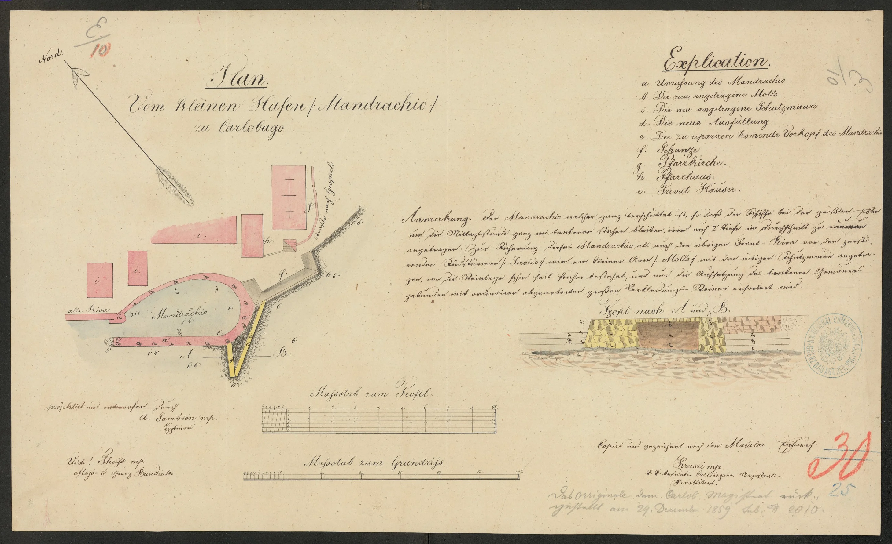
Remediation and expansion of the mandrač in Karlobag (year 1859)
This precious engineering study from December 1859 reveals a detailed plan for the transformation of the "Mandrachio" harbor. Unlike simple sketches, this project document provides a complete insight into solving one of the greatest problems of Karlobag at the time – the port's lack of protection from the devastating effects of the Sirocco wind.
The plans clearly show the intended works: the construction of a new pier (marked with the letter b) and the installation of a massive protective wall (marked with the letter c, shown in yellow). These elements were not merely an aesthetic upgrade, but a necessary defense designed to provide a calm anchorage for ships that were in constant danger in the old, exposed harbor.
The cross-sections of the construction (Profil nach A und B) are particularly valuable, demonstrating the high level of technical culture in the 19th century. Through precisely drawn measurements and the signatures of the then-frontier building director, we can see how the profession struggled with the whims of the Velebit Channel, turning the harbor into a safe maritime hub that became the heart of the Karlobag coast.
Illustration taken from the collection of the Croatian State Archives (HDA) in Zagreb,
HR-HDA-905 Construction blueprints, collection of the Croatian State Archives, 1663-1990, XXVI.1. Taken exclusively for educational and illustrative purposes.
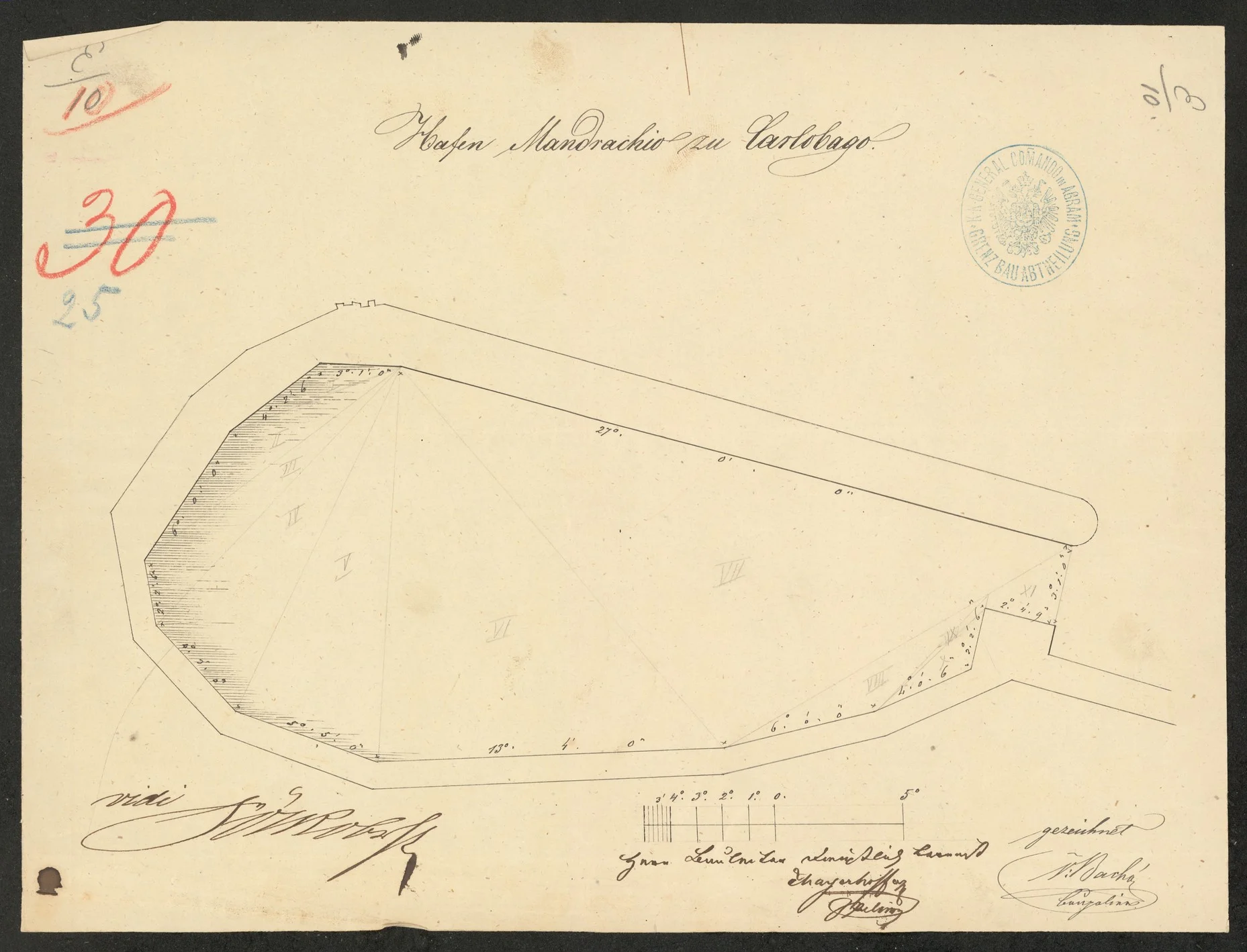
Geometric basis of the project: Plan of the mandrač (HDA-0003)
This document represents the second part of the comprehensive engineering project from 1859. While the first part (the cover plan) offers textual explanations and technical profiles, this ground plan (Grundriss) serves as a precise geometric basis. It defines in detail the shape of the harbor, divided into eight technical sections (marked with Roman numerals I-VIII), which enabled builders to perform accurate measurements on-site.
The document is the pinnacle of engineering documentation of that time, certified by the highest competent authorities for construction in the Military Frontier. In addition to the plan itself, key signatures and certifications are visible on the document:
- Project Architect: The plan was designed and drawn by A. Sambson.
- Main Supervision and Approval: The project was certified by the signature of Preiss, Major and Frontier Building Director (Major & Grenz Baudirector).
- Technical Draftsman: Frnuzic, the Imperial and Royal sworn construction referent of the Karlobag magistrate, is credited with the production of the copy and the technical precision.
This floor plan is not just a technical basis; it is proof of the high level of planning and responsibility that the authorities of the time had toward the safety of maritime traffic and the local community in Karlobag.
Illustration taken from the collection of the Croatian State Archives (HDA) in Zagreb,
HR-HDA-905 Construction blueprints, collection of the Croatian State Archives, 1663-1990, XXVI.1. Taken exclusively for educational and illustrative purposes.
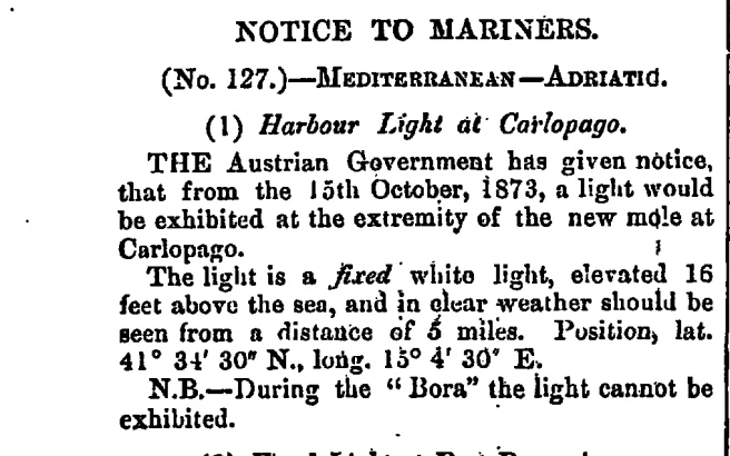
The crowning achievement: The first lighthouse and port safety
With the completion of the extensive works on the harbor and the construction of the protective pier (locally called Brač), Karlobag finally obtained a safe harbor basin. However, full functionality of the port was only achieved through the establishment of navigational safety, making this area a true maritime hub.
A historical step in navigation: On October 15, 1873, at the very end of the newly completed pier, the first lighthouse in the city's history was established. According to a notice published in the respected The London Gazette (November 28, 1873), it was a fixed white light elevated 16 feet (about 5 meters) above the sea, visible from a distance of 5 nautical miles. It was the technological peak of the port infrastructure at the time.
The challenge of the Velebit Bora: Despite the modernization, nature beneath the Velebit mountain remained relentless. Historical records from British archives reveal a dose of engineering realism of that time – alongside the technical data was an important warning: "N.B. — During the Bora, the light cannot be displayed."
This warning is a reminder of the fact that the force of the Bora often exceeded the technological capabilities of the 19th century. Nevertheless, the construction of the harbor and the installation of the lighthouse remain permanent symbols of Karlobag's rise as an important trading port, proving how engineers and sailors, with great effort, successfully dealt with the whims of the Velebit Channel.
Newspaper clipping taken from the official publication The London Gazette for educational/content purposes.
Be the first to like and share us